USGS 384041121410301 CACHE C SETTLING BASIN SITE B NR WOODLAND CA

PROVISIONAL DATA SUBJECT TO REVISION

Click to hidestation-specific text

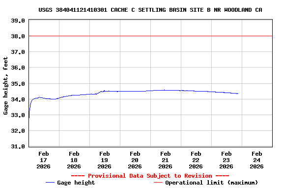
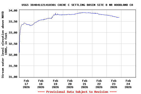
This station is operated seasonally (October - April).

> Rating Information
Available Parameters Available Period
  
2009-03-04  2025-11-19
2024-11-22  2025-11-19


 (7)
 

  -- or --


Summary of all available data for this site
Instantaneous-data availability statement


Gage height, feet

Most recent instantaneous value: 25.69 11-19-2025   21:45 PST
Graph of  Gage height, feet

Add up to 2 more sites and replot for "Gage height, feet"

?


Create presentation-quality / stand-alone graph.   Subscribe to WaterAlert      

See this graph on the Monitoring Location Pages


Stream water level elevation above NAVD 1988, in feet

Most recent instantaneous value: 25.02 11-19-2025   21:45 PST
Graph of  Stream water level elevation above NAVD 1988, in feet

Add up to 2 more sites and replot for "Stream water level elevation above NAVD 1988, in feet"

?


Create presentation-quality / stand-alone graph.   Subscribe to WaterAlert      

See this graph on the Monitoring Location Pages