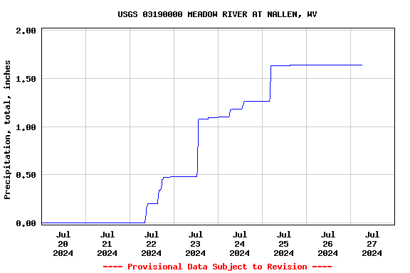
USGS 03190000 MEADOW RIVER AT NALLEN, WV

PROVISIONAL DATA SUBJECT TO REVISION

Click to hidestation-specific text
Station operated in cooperation with the U.S. Army Corps of Engineers - Huntington District and State of West Virginia

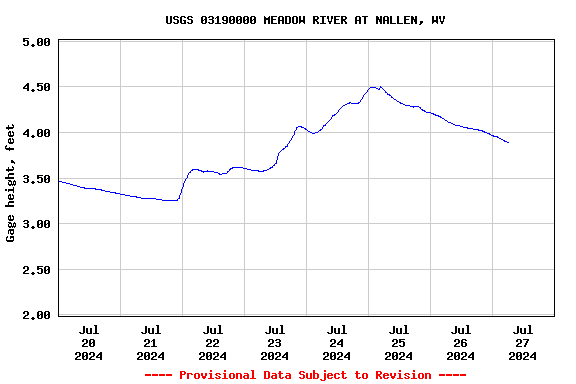
Current shift adjusted stage-discharge rating table. These tab delimited tables are updated daily and can change frequently. If you use these ratings, it is important that you update often so that you have the most current version.
What is a shift adjusted stage-discharge rating?
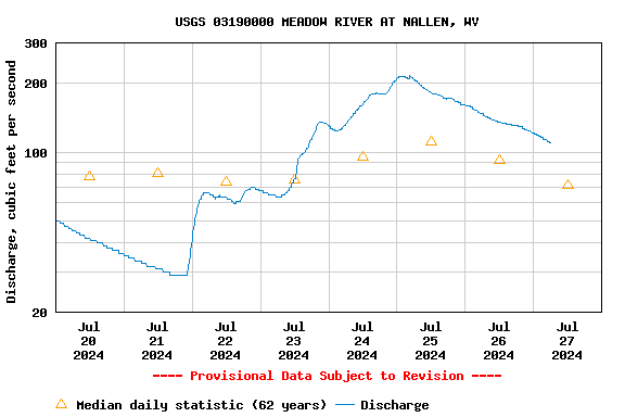
This station managed by the Charleston Field Office.

Available Parameters Available Period
  
2023-01-29  2023-05-30
2012-08-30  2023-05-30
2012-08-30  2023-05-30


 (7)
 

  -- or --


Summary of all available data for this site
Instantaneous-data availability statement


Precipitation, total, inches

Most recent instantaneous value: 0.00 05-30-2023   01:15 EDT
Graph of

Add up to 2 more sites and replot for "Precipitation, total, inches"

?


Create presentation-quality / stand-alone graph.   Subscribe to WaterAlert      

See this graph on the Monitoring Location Pages


Discharge, cubic feet per second

Most recent instantaneous value: 169 05-30-2023   01:15 EDT
Graph of

Add up to 2 more sites and replot for "Discharge, cubic feet per second"

?


Create presentation-quality / stand-alone graph.   Subscribe to WaterAlert      

See this graph on the Monitoring Location Pages


Daily discharge, cubic feet per second -- statistics for May 30 based on 54 water years of record more
Min
(1941)
25th
percen-
tile
Most Recent
Instantaneous
Value May 30
Median Mean 75th
percen-
tile
Max
(1956)
43.0 119 169 264 485 700 2190


Gage height, feet

Most recent instantaneous value: 4.17 05-30-2023   01:15 EDT
Graph of

Add up to 2 more sites and replot for "Gage height, feet"

?


Create presentation-quality / stand-alone graph.   Subscribe to WaterAlert      

See this graph on the Monitoring Location Pages