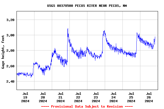
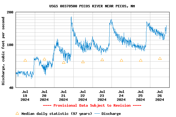
USGS 08378500 PECOS RIVER NEAR PECOS, NM

PROVISIONAL DATA SUBJECT TO REVISION

Click to hidestation-specific text
Station operated in cooperation with the National Streamflow Information Program.
This station managed by the Rio Arriba Field Office.

Available Parameters Available Period
  
1991-04-28  2024-04-23
2007-10-01  2024-04-23


 (7)
 

  -- or --


Summary of all available data for this site
Instantaneous-data availability statement


Discharge, cubic feet per second

Most recent instantaneous value: 356 04-23-2024   14:00 MDT
Graph of

Add up to 2 more sites and replot for "Discharge, cubic feet per second"

?


Create presentation-quality / stand-alone graph.   Subscribe to WaterAlert      

See this graph on the Monitoring Location Pages


Daily discharge, cubic feet per second -- statistics for Apr 23 based on 97 water years of record more
Min
(2018)
25th
percen-
tile
Median Mean 75th
percen-
tile
Most Recent
Instantaneous
Value Apr 23
Max
(1942)
28.7 84 142 190 247 356 1260


Gage height, feet

Most recent instantaneous value: 3.98 04-23-2024   14:00 MDT
Graph of

Add up to 2 more sites and replot for "Gage height, feet"

?


Create presentation-quality / stand-alone graph.   Subscribe to WaterAlert      

See this graph on the Monitoring Location Pages