PROVISIONAL DATA SUBJECT TO REVISION
Click to hidestation-specific text
Funding for this site is provided by:
 STATION.--01531325 SUGAR CREEK AT WEST BURLINGTON,
PA
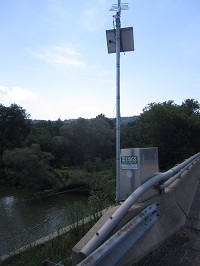
STATION.--01531325 SUGAR CREEK AT WEST BURLINGTON,
PALOCATION.--Lat 41`45'38", long 76`40'30", Bradford County, Hydrologic Unit 02050106, located on left bank, downstream side of bridge on State Route 3019, 0.25 mi south of West Burlington, 13 mi upstream from mouth.
DRAINAGE AREA.--93.6 square miles.
PERIOD OF RECORD.--July 2010 to current year.
GAGE.--Water-stage recorder and crest-stage gage. Datum of gage is 907.7 ft above North American Vertical Datum of 1988 (GNSS survey). Prior to November 4, 2024, the datum of gage was erroneously reported as 920 ft above National Geodetic Vertical Datum of 1929. Satellite telemetry at station.
COOPERATION.--Station established and maintained by the US Geological Survey. Funding for the operation of this station is provided by Repsol Oil & Gas USA.
Summary of all available data for this site
Instantaneous-data availability statement


