PROVISIONAL DATA SUBJECT TO REVISION
Click to hidestation-specific text
|
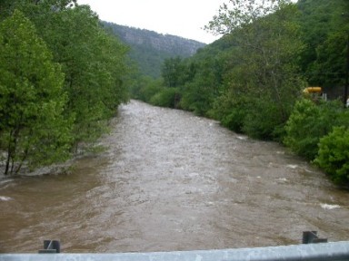 |
LOCATION.--Lat 39°40'10.6", long 78°47'16.9", Allegany County, MD, Hydrologic Unit 02070002,
   on right bank at downstream side of railway bridge, 0.15 mi downstream from Braddock Run,
   2.0 mi upstream from Cumberland, and mouth.
DRAINAGE AREA.--247 mi2.
PERIOD OF RECORD.--May 1905 to July 1906 (published as "at Cumberland"), October 1929 to current year.
REVISIONS HISTORY.--WSP 726: Drainage area. WSP 1432: 1906, 1930(M), 1933-34(M), 1936-37, 1945(M).
GAGE.--Water-stage recorder and crest-stage gage. Datum of gage is 640.27 ft above North American Vertical Datum
   of 1988. May 6, 1905, to July 14, 1906, nonrecording gage at highway bridge 700 ft upstream at different datum.
   Oct. 18, 1929, to Mar. 17, 1936, water-stage recorder, and Apr. 1, 1936, to Mar. 19, 1937, nonrecording gage
   at site 200 ft upstream at present gage datum.
REMARKS.--Records include drainage from  numerous active and abandoned coal mines. Groundwater flow is diverted
   into the basin from the Georges Creek basin by Hoffman Drainage Tunnel (see station 01601420, continuous record,
   July 2015 to July 2021). Miscellaneous measurements of discharge from the Hoffman Drainage Tunnel have been made in
   water years 1944, 1964-65, 1967-82, and 1984 by the U.S. Geological Survey, and in water years 1958 and 1959 by
   the Maryland Geological Survey. Slight diurnal fluctuation at low flow caused by quarry upstream. U.S. Army Corps
   of Engineers satellite data-collection platform at station.
EXTREMES FOR PERIOD OF RECORD.--Maximum discharge, 45,900 ft3/s, Jan. 19, 1996, gage height, 23.11 ft;
   minimum discharge, 9.0 ft3/s, Oct. 14, 1930.
COOPERATION.--Funding for the operation of this station is provided by the U.S. Army Corps of Engineers,
   and the U.S. Geological Survey.
| Boating safety tips |
Summary of all available data for this site
Instantaneous-data availability statement


