PROVISIONAL DATA SUBJECT TO REVISION
Click to hidestation-specific text
NOTICE (10/03/2011)--As of October 1, 2011, data collection at this streamgage has been discontinued due to funding reductions from partner agencies. Although historic data will remain accessible, no new data will be collected unless one or more new funding partners are found. Users who can contribute funding for the non-Federal share of costs to continue operation of this streamgage should contact Jon Dillow of the USGS Maryland, Delaware, DC, Water Science Center at 443-498-5524 or email at jjdillow@usgs.gov.
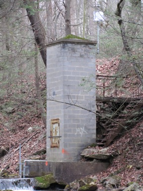
LOCATION.--Lat 39°31'37.7", long 77°28'01.3", Frederick County, Hydrologic Unit 02070009,
   on left bank immediately upstream from Fishing Creek Reservoir, 50 ft downstream from Little Fishing Creek,
   2.8 mi west of Lewistown, and 9.9 mi upstream from mouth.
DRAINAGE AREA.--7.29 mi2.
PERIOD OF RECORD.--October 1947 to September 1984, October 2009 to September 2010.
REVISED RECORDS.--WSP 1432:  Drainage area. WDR MD-DE-83-1: 1972-74, 1977-82 (P). WDR MD-DE-84-1: 1975-76 (P).
GAGE.--Water-stage recorder and concrete control. Elevation of gage is 735 ft above National Geodetic Vertical Datum of 1929.
REMARKS.--U.S. Geological Survey satellite data-collection platform at station.
COOPERATION.--Funding for the operation of this station is provided by the Maryland Department of the Environment,
   and the U.S. Geological Survey.
| Boating safety tips |
Summary of all available data for this site
Instantaneous-data availability statement