Warning: Javascript must be enabled to use all the features on this page!


Page Loading - Please Wait...

Click to hideNews Bulletins
  • Scheduled Maintenance Notice
    USGS will be performing maintenance on WDFN webpages beginning Tuesday, May 12.
    If you cannot access the page you are intending or are unexpectedly redirected to a different page, please reach out to wdfn@usgs.gov for assistance.

  • Explore the USGS National Water Dashboard interactive map to access real-time water data from over 13,500 stations nationwide.
! This page is undergoing modernization with expected decommissioning as key features are added to the modernized pages.
Learn more about our modernization plans to find out which options will suit you best. Next Generation Monitoring Location Page is available now.
A beta version of the My Favorites page is available in WDFN. Try it out and tell us what you think at wdfn@usgs.gov

USGS 03082500 Youghiogheny River at Connellsville, PA

PROVISIONAL DATA SUBJECT TO REVISION

Click to hidestation-specific text


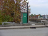
Station gage imageSTATION.--03082500 YOUGHIOGHENY RIVER AT CONNELLSVILLE, PA
LOCATION.--Lat 40`01'03", long 79`35'38", Fayette County, Hydrologic Unit 05020006, on left bank at downstream side of Crawford Avenue bridge at Connellsville, 1.2 mi upstream from Mounts Creek, and at mile 44.0.
DRAINAGE AREA.--1,326 square miles.
PERIOD OF RECORD.--July 1908 to current year. Monthly discharge only for some periods, published in WSP 1305.
GAGE.--Water-stage recorder. Datum of gage is 859.52 ft above North American Vertical Datum of 1988. Prior to Aug. 15, 1928, non-recording gage, and Aug. 15, 1928 to July 7, 1958, water-stage recorder at same site and datum. July 8, 1958 to Sept. 8, 1959, non-recording gage at site 0.4 mi downstream at different datum. Prior to January 4, 2024, the datum of gage was reported as 860.13 ft above National Geodetic Vertical Datum of 1929. Satellite telemetry at station.
COOPERATION.--Station esablished and maintained by the U.S. Geological Survey. Funding for the operation of this station is provided by U.S. Army Corps of Engineers, Pittsburgh District, the Pennsylvania Department of Environmental Protection and the U.S. Geological Survey.
REMARKS.--Flow regulated since 1925 by Deep Creek Reservoir, since 1943 by Youghiogheny River Lake 29.4 mi upstream, and by several smaller reservoirs above station.
GAGE HEIGHTS OF IMPORTANCE.-
Supplied by NWS: Action stage-9 ft; Flood stage-12 ft; Moderate flood stage-16 ft; Major flood stage-18 ft.
This station managed by the PAWSC Pittsburgh Field Office.

Available Parameters Available Period
  
1990-10-01  2026-05-18
2007-10-01  2026-05-18
2023-05-17  2026-05-18


 (7)
 

  -- or --


Summary of all available data for this site
Instantaneous-data availability statement


Discharge, cubic feet per second

Most recent instantaneous value: 1020 05-18-2026   08:15 EDT
Graph of

Add up to 2 more sites and replot for "Discharge, cubic feet per second"

?


Create presentation-quality / stand-alone graph.   Subscribe to WaterAlert      

See this graph on the Monitoring Location Pages


Daily discharge, cubic feet per second -- statistics for May 18 based on 101 water years of record more
Min
(1926)
Most Recent
Instantaneous
Value May 18
25th
percen-
tile
Median Mean 75th
percen-
tile
Max
(1978)
505 1020 1480 2500 3550 4420 16800


Gage height, feet

Most recent instantaneous value: 2.48 05-18-2026   08:15 EDT
Graph of

Add up to 2 more sites and replot for "Gage height, feet"

?


Create presentation-quality / stand-alone graph.   Subscribe to WaterAlert      

See this graph on the Monitoring Location Pages


Stream water level elevation above NAVD 1988, in feet

Most recent instantaneous value: 862.00 05-18-2026   08:15 EDT
Graph of

Add up to 2 more sites and replot for "Stream water level elevation above NAVD 1988, in feet"

?


Create presentation-quality / stand-alone graph.   Subscribe to WaterAlert      

See this graph on the Monitoring Location Pages