USGS 03498500 LITTLE RIVER NEAR MARYVILLE, TN

PROVISIONAL DATA SUBJECT TO REVISION

Click to hidestation-specific text


Boating safety tips
> WaterNow – get the latest gage data from your mobile phone or email.
> Rating Information
This station managed by the Knoxville Field Office.

Available Parameters Available Period
  
1989-10-01  2024-07-26
1984-03-22  2024-07-26


 (7)
 

  -- or --


Summary of all available data for this site
Instantaneous-data availability statement
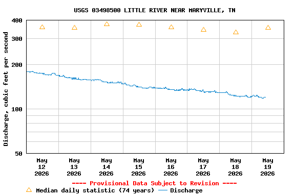

Discharge, cubic feet per second

Most recent instantaneous value: 263 07-26-2024   21:15 EDT
Graph of  Discharge, cubic feet per second

Add up to 2 more sites and replot for "Discharge, cubic feet per second"

?


Create presentation-quality / stand-alone graph.   Subscribe to WaterAlert      

See this graph on the Monitoring Location Pages


Daily discharge, cubic feet per second -- statistics for Jul 26 based on 73 water years of record more
Min
(1952)
25th
percen-
tile
Median Most Recent
Instantaneous
Value Jul 26
Mean 75th
percen-
tile
Max
(1962)
60.0 148 226 263 294 364 1780


Gage height, feet

Most recent instantaneous value: 5.93 07-26-2024   21:15 EDT
Graph of  Gage height, feet

Add up to 2 more sites and replot for "Gage height, feet"

?


Create presentation-quality / stand-alone graph.   Subscribe to WaterAlert      

See this graph on the Monitoring Location Pages