USGS 053813595 BLACK RIVER DS ST HWY 54 AT BLACK RIVER FALLS, WI

PROVISIONAL DATA SUBJECT TO REVISION

Click to hidestation-specific text

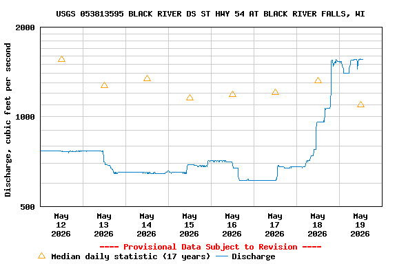
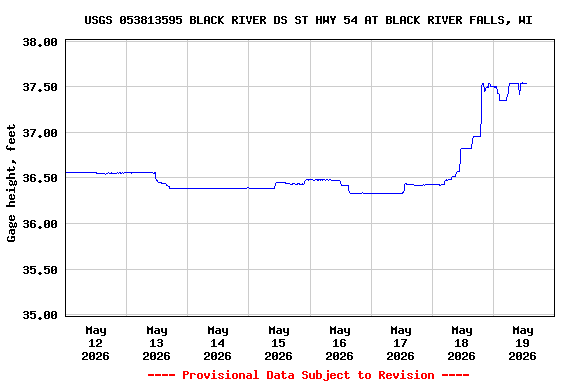
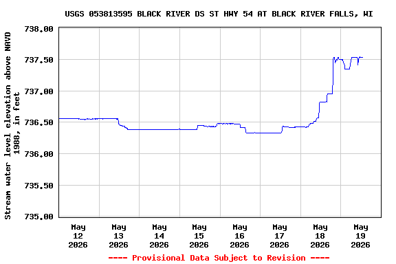
LOCATION.--Lat 44°17'37", long 90°50'47", in SE 1/4 SE 1/4 sec.15, T.21 N., R.4 W., JacksonCounty, Hydrologic Unit 07040007, on right bank 500 ft. downstream from bridge on state highway 54 in Black River Falls, 1000 ft. downstream from Town Creek and about 0.4 mi downstream from power plant.

DRAINAGE AREA.--1,590 square miles.

PERIOD OF RECORD.--October 2008 to present. October 1986 to October 2008 working data only.

GAGE.--Water-stage recorder and crest-stage gage. Datum of gage is 700.93 ft NAVD 1988.

REMARKS.--Cellular telemetry at station.

OPERATED IN COOPERATION WITH:

The City of Black River Falls

Additional Information:

National Weather Service Logo National Weather Service Flood Forecast Page

Boating safety tips
This station managed by the Wisconsin Water Science Center - Madison WI.

Available Parameters Available Period
  
2008-10-01  2024-03-19
2017-10-01  2024-03-19
2019-10-01  2024-03-19


 (7)
 

  -- or --


Summary of all available data for this site
Instantaneous-data availability statement


Discharge, cubic feet per second

Most recent instantaneous value: 527 03-19-2024   02:00 CDT
Graph of  Discharge, cubic feet per second

Add up to 2 more sites and replot for "Discharge, cubic feet per second"

?


Create presentation-quality / stand-alone graph.   Subscribe to WaterAlert      

See this graph on the Monitoring Location Pages


Daily discharge, cubic feet per second -- statistics for Mar 19 based on 15 water years of record more
Min
(2013)
Most Recent
Instantaneous
Value Mar 19
25th
percen-
tile
Median Mean 75th
percen-
tile
Max
(2016)
217 527 1640 2940 3830 4980 11800


Gage height, feet

Most recent instantaneous value: 36.40 03-19-2024   02:00 CDT
Graph of  Gage height, feet

Add up to 2 more sites and replot for "Gage height, feet"

?


Create presentation-quality / stand-alone graph.   Subscribe to WaterAlert      

See this graph on the Monitoring Location Pages


Stream water level elevation above NAVD 1988, in feet

Most recent instantaneous value: 736.40 03-19-2024   02:00 CDT
Graph of  Stream water level elevation above NAVD 1988, in feet

Add up to 2 more sites and replot for "Stream water level elevation above NAVD 1988, in feet"

?


Create presentation-quality / stand-alone graph.   Subscribe to WaterAlert      

See this graph on the Monitoring Location Pages