LOCATION.--Lat 41°57'52", long 95°58'21"
referenced to North American Datum of 1927, in NE 1/4 NE 1/4 NW 1/4
sec.33, T.83 N., R.44 W., Monona County, IA, Hydrologic Unit
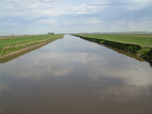
10230003, on left bank on downstream side of bridge on County Highway
E54, 3.8 mi south of Turin, 1.0 mi east of gaging station
Monona-Harrison Ditch near Turin (station 06602400), 2.5 mi
downstream from Maple River, and 13.4 mi upstream from mouth.
(map)
DRAINAGE AREA.--3,526 mi2.
SURFACE-WATER RECORDS
PERIOD OF RECORD.--Discharge records from May 1942 to September
1957, January 1958 to current year. June 1942 to January 1958, at
site 1,200 ft east on old river channel. Records are not equivalent
owing to diversion into Monona-Harrison Ditch through equalizer ditch
1.5 mi upstream from 1923 to 1958, and diversion with Monona-Harrison
Ditch through diversion ditch 8.3 miles upstream since 1958.
REVISED RECORDS.--WSP 1440: Drainage area. WSP 1560: Drainage
area. WDR IA-95-1: Period of record.
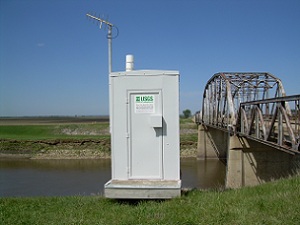
GAGE.--Water-stage recorder. Datum of gage is 1,019.85 ft above
National Geodetic Vertical Datum of 1929 (U.S. Army Corps of
Engineers benchmark). Prior to July 15, 1958, non-recording gages
near current site at different datums; July 15 to September 3, 1958,
non-recording gage at same site and datum.
WATER-QUALITY RECORDS
PERIOD OF RECORD.--October 2003 to current year.
PERIOD OF DAILY RECORD.--
SUSPENDED-SEDIMENT DISCHARGE: April 1939 to June 1948, October 1948
to September 1951, March to December 1959, March to November 1960,
March to November 1961, March to November 1962, March to November
1963, March 1964 to January 1965, April 1965 to June 1969, records
provided by U.S. Army Corps of Engineers.

 Site Information