USGS 06799000 Elkhorn River at Norfolk, Nebr.

PROVISIONAL DATA SUBJECT TO REVISION

Click to hidestation-specific text
Funding for this site is provided by
logo logo
Omaha District National Streamflow
Information Program
> WaterNow – get the latest gage data from your mobile phone or email.

> Rating Information

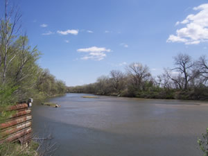
View downstream from USGS gaging station: Elkhorn River at Norfolk, Nebr.

Upstream Elkhorn River Basin Downstream

This station managed by the Lincoln Field Office.

Available Parameters Available Period
  
1990-10-01  2024-03-28
2007-10-01  2024-03-28


 (7)
 

  -- or --


Summary of all available data for this site
Instantaneous-data availability statement
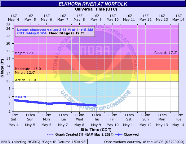

Discharge, cubic feet per second, [Discharge from Primary Sensor]

Most recent instantaneous value: 867 03-28-2024   08:15 CDT
Graph of  Discharge, cubic feet per second, [Discharge from Primary Sensor]

Add up to 2 more sites and replot for "Discharge, cubic feet per second, [Discharge from Primary Sensor]"

?


Create presentation-quality / stand-alone graph.   Subscribe to WaterAlert      

See this graph on the Monitoring Location Pages


Daily discharge, cubic feet per second -- statistics for Mar 28 based on 78 water years of record more
Min
(1981)
25th
percen-
tile
Median Most Recent
Instantaneous
Value Mar 28
Mean 75th
percen-
tile
Max
(1962)
312 430 632 867 1110 1260 6660


Gage height, feet, [Primary Stage Sensor]

Most recent instantaneous value: 3.19 03-28-2024   08:15 CDT
Graph of  Gage height, feet, [Primary Stage Sensor]

Add up to 2 more sites and replot for "Gage height, feet, [Primary Stage Sensor]"

?


Create presentation-quality / stand-alone graph.   Subscribe to WaterAlert      

See this graph on the Monitoring Location Pages