LOCATION.--Lat 41°00'31", long 95°14'29"
referenced to North American Datum of 1927, in NW 1/4 NW 1/4 SE 1/4
sec.29, T.72 N., R.38 W., Montgomery County, IA, Hydrologic Unit
10240003, on downstream side of bridge on Coolbaugh Street in Red
Oak, 0.2 mi upstream from Red Oak Creek, 38.1 mi upstream from
confluence with West Nishnabotna River, and 53.7 mi upstream from
mouth of Nishnabotna River. (map)
DRAINAGE AREA.--894 mi2.
SURFACE-WATER RECORDS
PERIOD OF RECORD.--Discharge records from May 1918 to July 1925,
May 1936 to current year. May 1918 to July 1925, monthly mean
discharge for some periods published in WSP 1310.
REVISED RECORDS.--WSP 1240: 1921, 1922-23 (M), 1924, 1942 (M),
1944 (M), 1946. WSP 1440: Drainage area. WSP 1710: 1957.
GAGE.--Water-stage recorder. Datum of gage is 1,005.45 ft above
National Geodetic Vertical Datum of 1929. Prior to July 5, 1925,
non-recording gage at same site at datum 4.60 ft higher; May 29,
1936, to November 14, 1952, non-recording gage at site 0.5 mi
upstream at datum 5.00 ft higher, with supplementary water-stage
recorder in operation above 3.2 ft gage height from March 22, 1951,
to November 14, 1952; November 15, 1952, to June 13, 1966,
water-stage recorder at site 0.5 mi upstream at datum 5.00 ft higher;
June 14, 1966, to September 30, 1969, water-stage recorder at same
site at datum 5.00 ft higher.
 Site Information
 Advanced
Hydrologic Prediction Service
Advanced
Hydrologic Prediction Service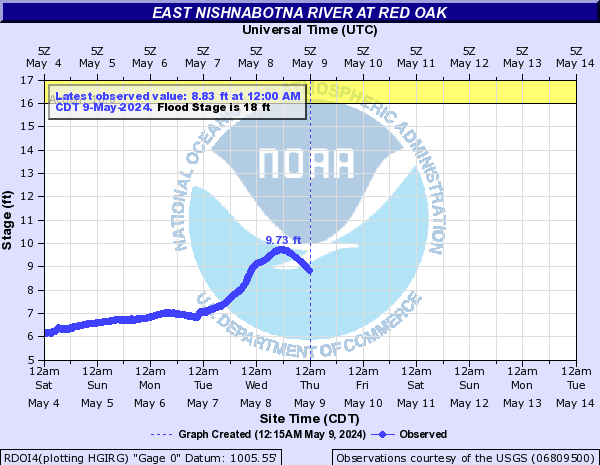






 U.S. Department of the Interior |
U.S. Geological Survey
U.S. Department of the Interior |
U.S. Geological Survey