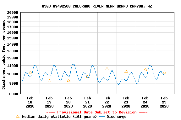
USGS 09402500 COLORADO RIVER NEAR GRAND CANYON, AZ

PROVISIONAL DATA SUBJECT TO REVISION

Click to hidestation-specific text
Station operated in cooperation with the Bureau of Reclamation and the USGS.

High Data Rate

This station managed by the Flagstaff Field Office; USGS AZ-WSC.

Available Parameters Available Period
  
1980-10-07  2024-07-27
2021-07-28  2024-07-27
2024-03-29  2024-07-27


 (7)
 

  -- or --


Summary of all available data for this site
Instantaneous-data availability statement


Discharge, cubic feet per second

Most recent instantaneous value: 10800 07-27-2024   07:15 MST
Graph of  Discharge, cubic feet per second

Add up to 2 more sites and replot for "Discharge, cubic feet per second"

?


Create presentation-quality / stand-alone graph.   Subscribe to WaterAlert      

See this graph on the Monitoring Location Pages


Daily discharge, cubic feet per second -- statistics for Jul 27 based on 99 water years of record more
Min
(1963)
Most Recent
Instantaneous
Value Jul 27
25th
percen-
tile
Median Mean 75th
percen-
tile
Max
(1983)
1220 10800 11800 14900 15000 18400 42100


Gage height, feet, [ENCODER]

Most recent instantaneous value: 7.84 07-27-2024   07:15 MST
Graph of  Gage height, feet, [ENCODER]

Add up to 2 more sites and replot for "Gage height, feet, [ENCODER]"

?


Create presentation-quality / stand-alone graph.   Subscribe to WaterAlert      

See this graph on the Monitoring Location Pages


Gage height, feet, [RADAR]

Most recent instantaneous value: 7.84 07-27-2024   07:15 MST
Graph of  Gage height, feet, [RADAR]

Add up to 2 more sites and replot for "Gage height, feet, [RADAR]"

?


Create presentation-quality / stand-alone graph.   Subscribe to WaterAlert      

See this graph on the Monitoring Location Pages