PROVISIONAL DATA SUBJECT TO REVISION
Click to hidestation-specific text
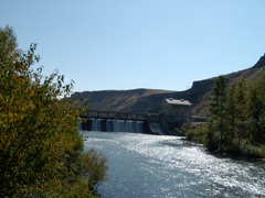
LOCATION.--Lat 43° 32'23", long 116° 05'37", in SE1/4 SE1/4 NE1/4 sec.4,
T.2 N., R.3 E., Ada County, Hydrologic Unit 17050114, on right bank,
700 ft downstream from Diversion Dam, and 7.0 mi southeast of Boise.
DRAINAGE AREA.--2,694 mi2, revised. Mean elevation, 5,910 ft.
PERIOD OF RECORD.--October 1986 to September 1994 (discontinued).
GAGE.---Water-stage recorder. Elevation of gage is 2,750 ft above NGVD of 1929,
from topographic map.
REMARKS.--Flow controlled by Diversion Dam 700 ft upstream of gage.
EXTREMES FOR PERIOD OF RECORD.--Maximum discharge, 7,480 ft3/s May 22, 1993,
gage height, 11.24 ft; minimum discharge, 20 ft3/s Nov. 5, 1992,
gage height, 5.03 ft.
Instantaneous-data availability statement