PROVISIONAL DATA SUBJECT TO REVISION
Click to hidestation-specific text
Funding for this site is provided by:
 Site Information
LOCATION.--Lat 42°44'00", long
77°54'40" referenced to North American Datum of 1927,
Livingston County, NY, Hydrologic Unit 04130002, at Mount
Morris Dam on Genesee River, 2.0 mi northwest of Mount Morris,
5.0 mi upstream from Canaseraga Creek, and 69.3 mi upstream
from mouth.
DRAINAGE AREA.--1,080 mi².
PERIOD OF RECORD.--January 1952 to current year. Prior to October 1970, published as "Mount Morris Reservoir near Mount Morris."
REVISIONS HISTORY.--WSP 1437: 1955. WDR NY-82-3: Drainage area.
GAGE.--Water-stage recorder. Datum of gage is NGVD of 1929 (Levels by U.S. Army Corps of Engineers). To convert elevations to NAVD of 1988, subtract 0.55 ft. Prior to Apr. 8, 1952, nonrecording gage at same site and datum.
COOPERATION.--Capacity table provided by U.S. Army Corps of Engineers, 1953.
REMARKS.--Lake is formed by a concrete gravity-type dam with overflow spillway, completed by U.S. Army Corps of Engineers in 1951 for flood control; first used for flood regulation on Nov. 24, 1951. Usable capacity, 336,800 acre-ft between elevation 585.0 ft, sill of conduits, and 760.0 ft, crest of spillway. Dead storage, 609 acre-ft. Figures given herein represent total contents. Discharge is controlled by the operation of nine gates. Water is stored during high flows and released when downstream conditions warrant.
EXTREMES FOR PERIOD OF RECORD.--Maximum elevation, 755.46 ft, June 25, 1972, contents, 322,600 acre-ft; minimum recordable elevation, 584.20 ft, Aug. 24-30, 1991, but was lower during this period due to dredging operations, contents, about 470 acre-ft.
DRAINAGE AREA.--1,080 mi².
PERIOD OF RECORD.--January 1952 to current year. Prior to October 1970, published as "Mount Morris Reservoir near Mount Morris."
REVISIONS HISTORY.--WSP 1437: 1955. WDR NY-82-3: Drainage area.
GAGE.--Water-stage recorder. Datum of gage is NGVD of 1929 (Levels by U.S. Army Corps of Engineers). To convert elevations to NAVD of 1988, subtract 0.55 ft. Prior to Apr. 8, 1952, nonrecording gage at same site and datum.
COOPERATION.--Capacity table provided by U.S. Army Corps of Engineers, 1953.
REMARKS.--Lake is formed by a concrete gravity-type dam with overflow spillway, completed by U.S. Army Corps of Engineers in 1951 for flood control; first used for flood regulation on Nov. 24, 1951. Usable capacity, 336,800 acre-ft between elevation 585.0 ft, sill of conduits, and 760.0 ft, crest of spillway. Dead storage, 609 acre-ft. Figures given herein represent total contents. Discharge is controlled by the operation of nine gates. Water is stored during high flows and released when downstream conditions warrant.
Capacity table (elevation, in feet, and total contents, in acre-feet)
Furnished by U.S. Army Corps of Engineers, 1955.

Elevation Contents         Elevation Contents        Elevation Contents
   582.0      175            605.0     8,250          680.0     119,800
   585.0      609            610.0    11,600          700.0     166,300
   588.0    1,210            620.0    19,800          730.0     245,200
   590.0    1,730            630.0    30,500          750.0     305,100
   595.0    3,410            640.0    43,700          760.0     337,400
   600.0    5,610            660.0    78,200          766.0     357,400
EXTREMES FOR PERIOD OF RECORD.--Maximum elevation, 755.46 ft, June 25, 1972, contents, 322,600 acre-ft; minimum recordable elevation, 584.20 ft, Aug. 24-30, 1991, but was lower during this period due to dredging operations, contents, about 470 acre-ft.
 WaterAlert – get an
email or text (SMS) alert based on your chosen threshold.
WaterAlert – get an
email or text (SMS) alert based on your chosen threshold.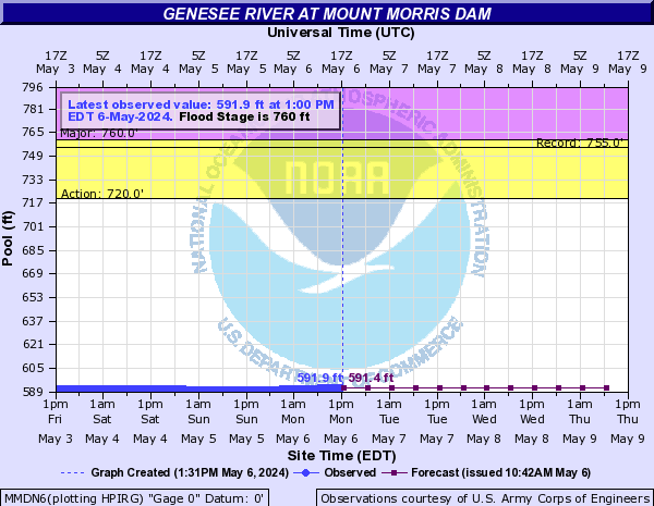
 Station image
Summary of all available data for this site
Instantaneous-data availability statement
![Graph of Lake or reservoir water surface elevation above NGVD 1929, feet, [COE Recorder]](https://natwebvaww02.er.usgs.gov/nwisweb/data/img/USGS.04224000.107583.62614..20240410.20240417..0..gif)
![Graph of Lake or reservoir water surface elevation above NAVD 1988, feet, [COE Recorder]](https://natwebvaww02.er.usgs.gov/nwisweb/data/img/USGS.04224000.245254.62615..20240410.20240417..0..gif)