PROVISIONAL DATA SUBJECT TO REVISION
Click to hidestation-specific text
The 15-minute precipitation data for this
station are temporary and will only be displayed for 120 days.
Although the instrumentation is calibrated at least once/year, the
temporary classification means that documented routine inspections and
other quality assurance measures are not performed that would make the
data acceptable for archival, retrieval, or future use in general
scientific or interpretive studies.
 Site Information
Funding for this site is provided by:
Site Information
LOCATION.--Lat 43°53'54.4", long
75°03'02.4" referenced to North American Datum of
1983, Herkimer County, NY, Hydrologic Unit 04150101, in gate
house at Stillwater Dam on Beaver River, 2.5 miles upstream
from Moshier Creek, and 7.5 miles west of Beaver River post
office.
DRAINAGE AREA.--171 mi².
PERIOD OF RECORD.--May 1908 to current year. Prior to February 1925, month-end contents only, published in WSP 1307. February 1925 to September 1937, published in WSP 824. Prior to October 1999, daily observations at 0800 hours.
REVISIONS HISTORY.--WDR NY-85-1: Drainage area.
GAGE.--Water-stage recorder. Reservoir elevation record is provided in Mean Sea Level, 4th General Adjustment of 1912 (not NGVD of 1929 as published), and NAVD of 1988 datums. To convert MSL1912 elevations to NAVD of 1988, add 0.55 ft. To convert MSL1912 elevations to NGVD of 1929, add 0.62 ft.
COOPERATION.--Supplemental elevation record and capacity table provided by Board of Hudson River-Black River Regulating District.
REMARKS.--Elevations listed herein are in ft above Mean Sea Level, 4th General Adjustment of 1912. Reservoir originally formed about 1885; enlarged at various times and in 1924 enlarged to a usable capacity of 4,623 mil ft³ between elevations 1,650.3 ft and 1,679.3 ft (top of 24-inch flashboards in place throughout year). Elevation of gate sill of lowest outlet, 1,642.3 ft. Capacity below elevation 1,650.3 ft, 100 mil ft³, is included in records presented herein, but is not ordinarily available for release. Figures given herein represent total contents. Reservoir is used to regulate flow of Beaver and Black Rivers for flood control, power development and general public welfare.
EXTREMES FOR PERIOD OF RECORD.--Maximum observed elevation, 1,680.15 ft above Mean Sea Level, 4th General Adjustment of 1912 (1,680.70 ft above NAVD of 1988), Apr. 29, 2011, contents, 4,969 mil ft³; minimum observed since first filling, 1,644.80 ft above Mean Sea Level, 4th General Adjustment of 1912 (1,645.35 ft above NAVD of 1988), Mar. 25-27, 1949, contents, 8 mil ft³.
DRAINAGE AREA.--171 mi².
PERIOD OF RECORD.--May 1908 to current year. Prior to February 1925, month-end contents only, published in WSP 1307. February 1925 to September 1937, published in WSP 824. Prior to October 1999, daily observations at 0800 hours.
REVISIONS HISTORY.--WDR NY-85-1: Drainage area.
GAGE.--Water-stage recorder. Reservoir elevation record is provided in Mean Sea Level, 4th General Adjustment of 1912 (not NGVD of 1929 as published), and NAVD of 1988 datums. To convert MSL1912 elevations to NAVD of 1988, add 0.55 ft. To convert MSL1912 elevations to NGVD of 1929, add 0.62 ft.
COOPERATION.--Supplemental elevation record and capacity table provided by Board of Hudson River-Black River Regulating District.
REMARKS.--Elevations listed herein are in ft above Mean Sea Level, 4th General Adjustment of 1912. Reservoir originally formed about 1885; enlarged at various times and in 1924 enlarged to a usable capacity of 4,623 mil ft³ between elevations 1,650.3 ft and 1,679.3 ft (top of 24-inch flashboards in place throughout year). Elevation of gate sill of lowest outlet, 1,642.3 ft. Capacity below elevation 1,650.3 ft, 100 mil ft³, is included in records presented herein, but is not ordinarily available for release. Figures given herein represent total contents. Reservoir is used to regulate flow of Beaver and Black Rivers for flood control, power development and general public welfare.
Capacity table (elevation, in feet, and total contents, in millions of cubic feet)

Elevation  Contents      Elevation  Contents
1,650.3       100        1,670.0     2,441
1,658.0       614        1,675.0     3,566
1,660.0       831        1,679.3     4,723
1,665.0     1,528        1,680.0     4,926
EXTREMES FOR PERIOD OF RECORD.--Maximum observed elevation, 1,680.15 ft above Mean Sea Level, 4th General Adjustment of 1912 (1,680.70 ft above NAVD of 1988), Apr. 29, 2011, contents, 4,969 mil ft³; minimum observed since first filling, 1,644.80 ft above Mean Sea Level, 4th General Adjustment of 1912 (1,645.35 ft above NAVD of 1988), Mar. 25-27, 1949, contents, 8 mil ft³.
 WaterAlert – get an
email or text (SMS) alert based on your chosen threshold.
WaterAlert – get an
email or text (SMS) alert based on your chosen threshold.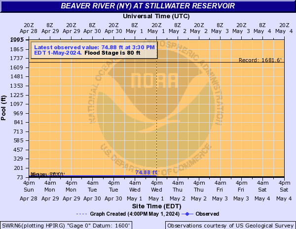
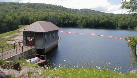 Station image
Summary of all available data for this site
Instantaneous-data availability statement

![Graph of Lake or reservoir water surface elevation above NGVD 1929, feet, [MSL, Adjustment of 1912]](https://natwebsdww02.cr.usgs.gov/nwisweb/data/img/USGS.04256500.107783.62614..20240825.20240901..0..gif)
