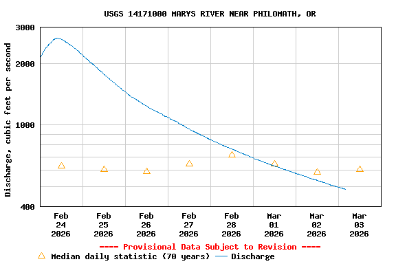
USGS 14171000 MARYS RIVER NEAR PHILOMATH, OR

PROVISIONAL DATA SUBJECT TO REVISION

Click to hidestation-specific text

Station funded by U.S. Geological Survey National Streamflow Information Program (NSIP).

NOTE: River forecasts and additional data can be obtained at the 
National Weather Service's Advanced Hydrologic Prediction Services web page.

NOTE: The most current shifted rating for this site can be found at USGS Rating Depot website.
Boating safety tips
Available Parameters Available Period
  
2023-07-31  2026-02-19
2000-10-01  2026-02-19
2007-10-01  2026-02-19


 (7)
 

  -- or --


Summary of all available data for this site
Instantaneous-data availability statement


Discharge, cubic feet per second

Most recent instantaneous value: 404 02-19-2026   22:00 PST
Graph of  Discharge, cubic feet per second

Add up to 2 more sites and replot for "Discharge, cubic feet per second"

?


Create presentation-quality / stand-alone graph.   Subscribe to WaterAlert      

See this graph on the Monitoring Location Pages


Daily discharge, cubic feet per second -- statistics for Feb 20 based on 70 water years of record more
Min
(1977)
Most Recent
Instantaneous
Value Feb 20
25th
percen-
tile
Median Mean 75th
percen-
tile
Max
(1949)
21.5 404 439 687 1010 1340 4170