All 28 Available Parameters for this site
00010 Temperature, water 2009-01-22 2026-03-06
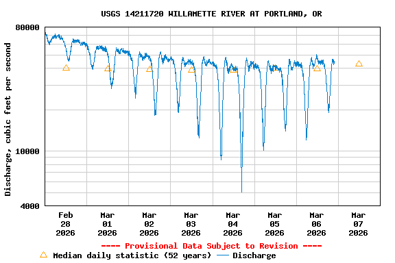
00060 Discharge 1988-10-01 2026-03-06
00065 Gage height, Morrison Bridge 2007-10-01 2026-03-06
00095 Specific cond at 25C 2009-01-22 2026-03-06
00300 Dissolved oxygen 2009-01-22 2026-03-06
00400 pH 2009-01-22 2026-03-06
32295 fDOM, water, in situ 2023-03-05 2026-03-06
32315 Relative fChl, water, in situ 2024-08-21 2026-03-06
32321 Relative fPC, water, in situ 2024-08-21 2026-03-06
62361 Chlorophyll, in situ 2009-01-22 2024-08-21
63680 Turbidity, Form Neph 2009-01-22 2026-03-06
72137 Discharge,tide fltrd 2007-10-01 2026-03-05
72147 Depth, sensor [Depth accuracy is variable] 2009-01-22 2026-03-06
72255 Mean water velocity, Broadway Bridge [Broadway Bridge] 2018-10-01 2026-03-06
80297 SS load, regres ss, Broadway Bridge [Total Suspended Sediment] 2016-10-01 2026-03-06
80297 SS load, regres ss, Broadway Bridge [Suspended Sands (>62 microns)] 2023-03-05 2026-03-06
80297 SS load, regres ss, Broadway Bridge [Suspended Fines (<62 microns)] 2023-03-05 2026-03-06
95204 Cyanobacteria, IVF 2023-03-05 2024-08-21
99137 Nitrate, in situ 2023-03-05 2026-03-06
99246 Upper 90% limit, SSC, Broadway Bridge [Total Suspended Sediment] 2023-03-05 2026-03-06
99246 Upper 90% limit, SSC, Broadway Bridge [Suspended Sands (>62 microns)] 2023-03-05 2026-03-06
99246 Upper 90% limit, SSC, Broadway Bridge [Suspended Fines (<62 microns)] 2023-03-08 2026-03-06
99247 Lower 90% limit, SSC, Broadway Bridge [Total Suspended Sediment] 2023-03-05 2026-03-06
99247 Lower 90% limit, SSC, Broadway Bridge [Suspended Sands (>62 microns)] 2023-03-05 2026-03-06
99247 Lower 90% limit, SSC, Broadway Bridge [Suspended Fines (<62 microns)] 2023-03-08 2026-03-06
99409 Susp sediment,wu,est, Broadway Bridge [Total Suspended Sediment] 2016-10-01 2026-03-06
99409 Susp sediment,wu,est, Broadway Bridge [Suspended Fines (<62 microns)] 2016-10-01 2026-03-06
99409 Susp sediment,wu,est, Broadway Bridge [Suspended Sands (>62 microns)] 2016-10-01 2026-03-06