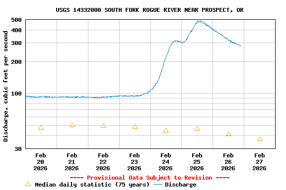
USGS 14332000 SOUTH FORK ROGUE RIVER NEAR PROSPECT, OR

PROVISIONAL DATA SUBJECT TO REVISION

Click to hidestation-specific text

Station operated in cooperation with PacifiCorp.

NOTE: The most current shifted rating for this site can be found at USGS Rating Depot website.
Boating safety tips
Available Parameters Available Period
  
1988-11-03  2025-12-15
2007-10-01  2025-12-15


 (7)
 

  -- or --


Summary of all available data for this site
Instantaneous-data availability statement


Discharge, cubic feet per second

Most recent instantaneous value: 84.8 12-15-2025   01:30 PST
Graph of  Discharge, cubic feet per second

Add up to 2 more sites and replot for "Discharge, cubic feet per second"

?


Create presentation-quality / stand-alone graph.   Subscribe to WaterAlert      

See this graph on the Monitoring Location Pages


Daily discharge, cubic feet per second -- statistics for Dec 15 based on 75 water years of record more
Min
(1970)
25th
percen-
tile
Median Most Recent
Instantaneous
Value Dec 15
75th
percen-
tile
Mean Max
(1984)
0.35 5 21 84.8 99 103 1820