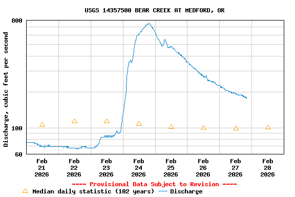
USGS 14357500 BEAR CREEK AT MEDFORD, OR

PROVISIONAL DATA SUBJECT TO REVISION

Click to hidestation-specific text

Station operated in cooperation with the Bureau of Reclamation.

NOTE: River forecasts and additional data can be obtained at the 
National Weather Service's Advanced Hydrologic Prediction Services web page.

NOTE: The most current shifted rating for this site can be found at USGS Rating Depot website.
Boating safety tips
Available Parameters Available Period
  
1988-10-01  2026-02-07
2007-10-01  2026-02-07


 (7)
 

  -- or --


Summary of all available data for this site
Instantaneous-data availability statement


Discharge, cubic feet per second

Most recent instantaneous value: 44.3 02-07-2026   06:15 PST
Graph of  Discharge, cubic feet per second

Add up to 2 more sites and replot for "Discharge, cubic feet per second"

?


Create presentation-quality / stand-alone graph.   Subscribe to WaterAlert      

See this graph on the Monitoring Location Pages


Daily discharge, cubic feet per second -- statistics for Feb 7 based on 102 water years of record more
Min
(1931)
Most Recent
Instantaneous
Value Feb 7
25th
percen-
tile
Median Mean 75th
percen-
tile
Max
(2015)
16.0 44.3 54 90 232 257 1760