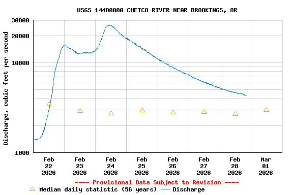
USGS 14400000 CHETCO RIVER NEAR BROOKINGS, OR

PROVISIONAL DATA SUBJECT TO REVISION

Click to hidestation-specific text

Station operated in cooperation with the City of Brookings and Oregon South Coast Fisherman.

NOTE: River forecasts and additional data can be obtained at the 
National Weather Service's Advanced Hydrologic Prediction Services web page.

NOTE: The most current shifted rating for this site can be found at USGS Rating Depot website.

NOTE: Specific Gage Analysis and Discharge Measurement Cross Sections can be found here.
Boating safety tips
Available Parameters Available Period
  
2023-09-11  2025-12-10
1988-10-01  2025-12-10
2007-10-01  2025-12-10


 (7)
 

  -- or --


Summary of all available data for this site
Instantaneous-data availability statement


Discharge, cubic feet per second

Most recent instantaneous value: 654 12-10-2025   06:30 PST
Graph of

Add up to 2 more sites and replot for "Discharge, cubic feet per second"

?


Create presentation-quality / stand-alone graph.   Subscribe to WaterAlert      

See this graph on the Monitoring Location Pages


Daily discharge, cubic feet per second -- statistics for Dec 10 based on 56 water years of record more
Min
(1977)
Most Recent
Instantaneous
Value Dec 10
25th
percen-
tile
Median Mean 75th
percen-
tile
Max
(1988)
151 654 1150 2690 4690 5240 27800