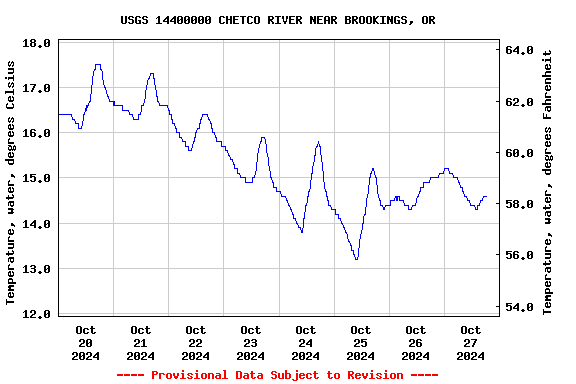
Most recent instantaneous value: 14.5 10-27-2024 16:30 PDT
See this graph on the Monitoring Location Pages
Station operated in cooperation with the City of Brookings and Oregon South Coast Fisherman.
NOTE: River forecasts and additional data can be obtained at the
National Weather Service's Advanced Hydrologic Prediction Services web page.

NOTE: The most current shifted rating for this site can be found at USGS Rating Depot website.

NOTE: Specific Gage Analysis and Discharge Measurement Cross Sections can be found here.
| Boating safety tips |
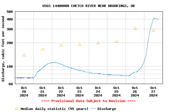
| Min (1988) | 25th percen- tile | Median | Most Recent Instantaneous Value Oct 27 | 75th percen- tile | Mean | Max (2017) |
|---|---|---|---|---|---|---|
| 49.0 | 95 | 286 | 400 | 1010 | 1040 | 9680 |
![]() U.S. Department of the Interior |
U.S. Geological Survey
U.S. Department of the Interior |
U.S. Geological Survey
Title: USGS Current Conditions for Oregon
URL:
Page Contact Information: Oregon Water Data Support Team
Page Last Modified: 2024-10-27 20:32:04 EDT
1.98 1.56 sdww01