USGS 13333000 GRANDE RONDE RIVER AT TROY, OR

PROVISIONAL DATA SUBJECT TO REVISION

Click to hidestation-specific text

Station operated in cooperation with the U.S. Army Corps of Engineers Walla Walla District and Confederated Tribes of the Umatilla Indian Reservation (CTUIR).


NOTE: River forecasts and additional data can be obtained at the 
National Weather Service's Advanced Hydrologic Prediction Services web page.

NOTE: The most current shifted rating for this site can be found at USGS Rating Depot website.
Boating safety tips
Available Parameters Available Period
  
2024-03-26  2024-10-06
1989-03-21  2024-10-06
2007-10-01  2024-10-06


 (7)
 

  -- or --


Summary of all available data for this site
Instantaneous-data availability statement


Discharge, cubic feet per second

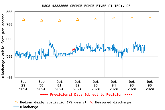
Most recent instantaneous value: 546 10-06-2024   04:00 PDT
Graph of

Add up to 2 more sites and replot for "Discharge, cubic feet per second"

?


Create presentation-quality / stand-alone graph.   Subscribe to WaterAlert      

See this graph on the Monitoring Location Pages


Daily discharge, cubic feet per second -- statistics for Oct 6 based on 80 water years of record more
Min
(2002)
Most Recent
Instantaneous
Value Oct 6
25th
percen-
tile
Median Mean 75th
percen-
tile
Max
(1960)
489 546 652 746 769 867 1500