Funding for this site is provided by:
 STATION.
--01554000 SUSQUEHANNA RIVER AT SUNBURY,
PA
LOCATION.--Lat 40`50'04", long
76`49'37", Snyder County, Hydrologic Unit 02050301, on right
bank at borough of Shamokin Dam, on grounds of Sunbury Generation LP,
1.0 mi downstream from Shamokin Creek, 1.5 mi downstream from Sunbury
Fabridam, and 1.8 mi south of Sunbury.
DRAINAGE AREA.--18,300 square miles, approximately
(excluding that of Shamokin Creek).
PERIOD OF RECORD.--October 1937 to current year. June
1918 to September 1918 (gage heights only), in reports of Pennsylvania
Department of Forests and Waters.
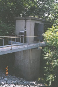
GAGE.--Water-stage recorder. Datum of gage is 407.90
ft above North American Vertical Datum of 1988. See WSP 1903 for
history of changes prior to Dec. 13, 1937. Dec. 13, 1937, to Mar. 23,
1967, water-stage recorder at site 1.7 mi upstream at datum 11.05 ft
higher. Prior to November 9, 2022, the datum was reported as 408.61 ft
above NGVD29.
COOPERATION.--Station established and maintained by
the U.S. Geological Survey. Funding for the operation of this station
is provided by the Pennsylvania Department of Environmental Protection
and the U.S. Geological Survey.
REMARKS.--Flow slightly regulated by 14 flood-control
reservoirs which have a capacity of about 809,000 acre-ft, and during
low flow by Fabridam, forming Lake Augusta located 1.5 mi
upstream.
GAGE HEIGHTS OF IMPORTANCE.--
Supplied by USGS: Maximum recordable gage height
(stage sensor operational limit) - 39.9 ft; Data transmitter
operational limit - 40.7 ft;
Supplied by NWS: Action stage-20 ft, river interests
encouraged to monitor conditions; Shikellamy State Park closed due to
high water; Flood stage-24 ft, both banks overflow; areas not protected
by flood wall and levee system are affected; Moderate flood stage-26
ft, high water affects a number of homes and businesses in areas not
protected by flood wall and levee system; Major flood stage-34 ft, most
areas adjacent to river which are not protected by flood wall and levee
system are affected by high water. Catastrophic flooding occurs in some
of these areas.

![[!]](https://pa.water.usgs.gov/images/exclaim.gif) Over the
next year, the USGS Pennsylvania Water Science Center will be updating
the geodetic vertical elevation (gage datum) for many locations. Click
HERE for additional information including a current list of
streamgages with upcoming datum changes. This update in gage datum does
not affect the location of the streamgage, nor the observed local gage
height or discharge recorded at the streamgage.
Over the
next year, the USGS Pennsylvania Water Science Center will be updating
the geodetic vertical elevation (gage datum) for many locations. Click
HERE for additional information including a current list of
streamgages with upcoming datum changes. This update in gage datum does
not affect the location of the streamgage, nor the observed local gage
height or discharge recorded at the streamgage.
