PROVISIONAL DATA SUBJECT TO REVISION
Click to hidestation-specific text
Funding for this site is provided by:
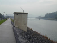
 STATION.--01545800 WEST BRANCH SUSQUEHANNA RIVER AT
LOCK HAVEN, PA
 LOCATION.--Lat 41`08'17", long 77`26'32", Clinton County, Hydrologic Unit 02050203, on right bank 1250 ft downstream from Jay Street bridge, and 2.1 mi upstream from Bald Eagle Creek.
DRAINAGE AREA.--3,345 square miles.
PERIOD OF RECORD.--1975 to current year.
GAGE.--Water-stage recorder and concrete control. Datum of gage is 534.52 ft above North American Vertical Datum of 1988. Satellite telemetry at station.
COOPERATION.--Funding for the operation of this station is provided by the Pennsylvania Department of Environmental Protection and the U.S. Geological Survey.
REMARKS.--Daily discharge not available from 1975 through September 2017.
GAGE HEIGHTS OF IMPORTANCE.-
Supplied by USGS: Maximum recordable gage height (stage sensor operational limit) - 40.9 ft; Data transmitter operational limit - 42.3 ft; 39 feet at top of levee.
Supplied by NWS: Action stage-17 ft, monitor for rising waters; homes downstream along Antes Creek affected; Flood stage-21 ft, the right or south bank overflows in areas not protected by levee system; Moderate flood stage-23 ft, considerable flooding if levee not in place; Major flood stage-25 ft, numerous homes and businesses would be flooded if levee not in place.
Summary of all available data for this site
Instantaneous-data availability statement
