PROVISIONAL DATA SUBJECT TO REVISION
Click to hidestation-specific text
Funding for this site is provided by:
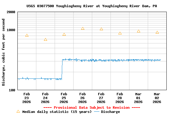
STATION.--03077500 YOUGHIOGHENY RIVER AT YOUGHIOGHENY RIVER DAM, PA.
LOCATION.--Lat 39`48'19", long 79`21'52", Somerset County, Hydrologic Unit 05020006.
DRAINAGE AREA.--436 square miles.
PERIOD OF RECORD.--September 1904 to September 1913 (gage heights only), October 1939 to September 1991, 2005 -2008 (discharge measurements only), 2009 to current year.
GAGE.--Water-stage recorder and acoustic Doppler velocity meter (installed October 2011). Elevation of gage is 1,309.7 ft above North American Vertical Datum of 1988. Prior to January 16, 2024, the datum of gage was reported as 1,310.17 ft above National Geodetic Vertical Datum of 1929. Satellite telemetry at station.
COOPERATION.--Station established and maintained by the U.S. Geological Survey in cooperation with the U.S. Army Corps of Engineers, Pittsburgh District.
REMARKS.--Flow regulated since 1925 by Deep Creek Reservoir and since 1943 by Youghiogheny River Lake 0.2 mi. upstream.
Instantaneous-data availability statement