PROVISIONAL DATA SUBJECT TO REVISION
Click to hidestation-specific text
Funding for this site is provided by:
 STATION.--01532000 TOWANDA CREEK NEAR MONROETON, PA
LOCATION.--Lat 41`42' 27", long 76`29' 07", Bradford County, Hydrologic Unit 02050106, on left bank on Township Route 406, 0.8 mi southwest of Monroeton, and 1.0 mi upstream from South Branch Towanda Creek.
DRAINAGE AREA.--215 square miles.
PERIOD OF RECORD.--February 1914 to current year.
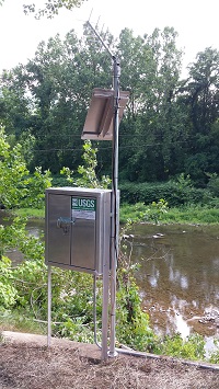
GAGE.--Water-stage recorder and crest-stage gage. Datum of gage is 764.84 ft above North American Vertical Datum of 1988. Prior to Oct. 1942, non-recording gage at site 85 ft downstream at datum 8.62 ft higher. Water-stage recorder Oct. 1942 to Sept. 1975, 0.6 mi downstream at datum 11.82 ft lower. Non-recording gage Sept. 1975 to Aug. 1976, at bridge 0.6 mi downstream at datum 11.82 ft lower. Non-recording gage Aug. 1976 to Oct. 1977, at site 85 ft. downstream at present datum. Water-stage recorder Oct. 1977 to Sep. 2017 at site 85 ft downstream, at present datum. Satellite telemetry at station. Prior to November 10, 2022, the datum of gage was reported as 765.53 ft above National Geodetic Vertical Datum of 1929.
COOPERATION.--Funding for the operation of this station is provided by the Pennsylvania Department of Environmental Protection and the U.S. Geological Survey.
GAGE HEIGHTS OF IMPORTANCE.--
Supplied by USGS: Data transmitter operational limit - 26.2 ft;
Supplied by NWS: Action stage-12 ft, bankfull stage, cautionary stage for officials to monitor area; Flood stage-15.5 ft, water begins to spread into backyards of homes near creek southwest of Monroeton; Moderate flood stage-17 ft; Major flood stage-18.5 ft;
Summary of all available data for this site
Instantaneous-data availability statement

