PROVISIONAL DATA SUBJECT TO REVISION
Click to hidestation-specific text



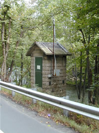 STATION.--01534500 LACKAWANNA RIVER AT ARCHBALD,
PA
STATION.--01534500 LACKAWANNA RIVER AT ARCHBALD,
PALOCATION.--Lat 4l`30'16", long 75`32'33", Lackawanna County, Hydrologic Unit 02050107, on right bank along SR 1012 in Archbald, and 0.5 mi upstream from White Oak Run and Gilmartin Street bridge.
DRAINAGE AREA.--108 square miles.
PERIOD OF RECORD.--October 1939 to current year. Prior to February 1940 monthly discharge only, published in WSP 1302.
GAGE.--Water-stage recorder. Datum of gage is 888.66 ft above North American Vertical Datum of 1988 (from benchmark). Prior to March 13, 2024, the datum of gage was reported as 889.33 ft above National Geodetic Vertical Datum of 1929. Satellite and cellular telemetry at station.
COOPERATION.--Station established and maintained by the U.S. Geological Survey. Funding for the operation of this station is provided by the U.S. Army Corps of Engineers, Baltimore District, the Pennsylvania Department of Environmental Protection, and the U.S. Geological Survey.
GAGE HEIGHTS OF IMPORTANCE.-
Supplied by USGS: Maximum recordable gage height (stage sensor operational limit) - 19.2 ft; Data transmitter operational limit - 20.4 ft;
Supplied by NWS: Action stage-6.2 ft; Flood stage-8 ft; Moderate flood stage-9 ft; Major flood stage-10 ft.
Summary of all available data for this site
Instantaneous-data availability statement


