PROVISIONAL DATA SUBJECT TO REVISION
Click to hidestation-specific text
Funding for this site is provided by:


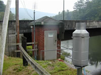 STATION.--01548500 PINE CREEK AT CEDAR RUN, PA
LOCATION.--Lat 41`31'18", long 77`26'52", Lycoming County, Hydrologic Unit 02050205, on left bank at upstream side of highway bridge on Township Route 762 at village of Cedar Run, 2,000 ft downstream from Cedar Run, and 1.2 mi upstream from Gamble Run.
DRAINAGE AREA.--604 square miles.
PERIOD OF RECORD.--July 1918 to current year. Prior to October 1918 monthly discharge only, published in WSP 1302.
GAGE.--Water-stage recorder and weighing bucket precipitation gage. Datum of gage is 779.80 ft above North American Vertical Datum of 1988. Prior to Feb. 13, 1930, non-recording gage at same site and datum. Prior to March 14, 2024, the datum of gage was reported as 780.36 ft above National Geodetic Vertical Datum of 1929. Satellite telemetry at station.
COOPERATION.--Funding for the operation of this station is provided by the Pennsylvania Department of Environmental Protection, and the U.S. Geological Survey.
REMARKS.--
| The 15-minute precipitation data for this station are temporary and will only be displayed for 120 days. Time series of 1-hour or cumulative daily values will NOT be available for retrieval following the 120-day display period. Although the instrumentation is calibrated at least once a year, the temporary classification means that documented routine inspections and other quality assurance measures are not performed that would make the data acceptable for archival, retrieval, or future use in general scientific or interpretive studies. |
GAGE HEIGHTS OF IMPORTANCE.-
Supplied by USGS: Maximum recordable gage height (stage sensor operational limit) - 17.3 ft; Data transmitter operational limit - 18.7 ft;
Supplied by NWS: Action stage-7 ft, river interests monitor conditions; Flood stage-12 ft, few residences along left bank of Pine Creek in vicinity of Cedar Run are inundated; some homes and cabins in vicinity of Jersey Mills affected; Moderate flood stage-13 ft, high water affects numerous homes and cabins from Cedar Run downstream; Major flood stage-15 ft, many homes and cabins along Pine Creek are affected by high water.
Summary of all available data for this site
Instantaneous-data availability statement


