PROVISIONAL DATA SUBJECT TO REVISION
Click to hidestation-specific text
Funding for this site is provided by:
 STATION.--01551500 WEST BRANCH SUSQUEHANNA RIVER AT
WILLIAMSPORT, PA
STATION.--01551500 WEST BRANCH SUSQUEHANNA RIVER AT
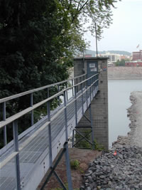
WILLIAMSPORT, PALOCATION.--Lat 41`14'10", long 76`59'49", Lycoming County, Hydrologic Unit 02050206, on right bank 100 ft upstream from Market Street bridge at South Williamsport, and 350 ft upstream from Hagermans Run.
DRAINAGE AREA.--5,682 square miles.
PERIOD OF RECORD.--March 1895 to current year.
GAGE.--Water-stage recorder and crest-stage gage. Datum of gage is 494.27 ft above North American Vertical Datum of 1988. Mar. 1, 1895, to Sept. 30, 1928, non-recording gage at bridge 100 ft downstream at same datum. Prior to July 1980, 100 ft downstream on left bank at same datum. Prior to March 14, 2024, the datum of gage was reported as 494.98 ft above National Geodetic Vertical Datum of 1929. Satellite and landline telemetry at station.
COOPERATION.--Funding for the operation of this station is provided by the Pennsylvania Department of Environmental Protection, the City of Williamsport, and the U.S. Geological Survey.
GAGE HEIGHTS OF IMPORTANCE.-
Supplied by USGS: Maximum recordable gage height (stage sensor operational limit) - 41.0 ft; Data transmitter operational limit - 42.4 ft;
Supplied by NWS: Action stage-10 ft; Flood stage-20 ft, high water affects a few homes and some roadways in areas not protected by levee system; camping area west of Williamsport significantly affected; Moderate flood stage-21 ft, a number of residences and roads in the area outside the levee system are affected; Major flood stage-30 ft, many homes and businesses outside the levee system are affected by high water.
Summary of all available data for this site
Instantaneous-data availability statement

