PROVISIONAL DATA SUBJECT TO REVISION
Click to hidestation-specific text
Funding for this site is provided by:
Interactive Flood Inundation Map Available
 STATION.--01553500 WEST BRANCH SUSQUEHANNA RIVER AT
LEWISBURG, PA
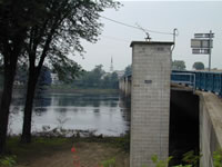
STATION.--01553500 WEST BRANCH SUSQUEHANNA RIVER AT
LEWISBURG, PA LOCATION.--Lat 40`58'03", long 76`52'36", Northumberland County, Hydrologic Unit 02050206, at downstream side of left abutment of Market Street bridge on State Highway 45 at Lewisburg, 0.2 mi downstream from Buffalo Creek, and 7.4 mi upstream from mouth.
DRAINAGE AREA.--6,847 square miles.
PERIOD OF RECORD.--October 1939 to current year. September 1913 to August 1923 (gage heights only), are contained in reports of Water Supply Commission of Pennsylvania or Pennsylvania Department of Forests and Waters.
GAGE.--Water-stage recorder. Datum of gage is 427.45 ft above North American Vertical Datum of 1988 (from benchmark). Sept. 21, 1913, to Aug. 31, 1923, Dec. 7, 1939, to July 2, 1940, and Oct. 20, 1987, to Sept. 30, 1988, non-recording gage at same site and datum. Prior to March 15, 2024, the datum of gage was reported as 428.20 ft above National Geodetic Vertical Datum of 1929. Since Oct. 1, 1942, water-stage recorder for Susquehanna River at Sunbury (station 01553990) used as an auxiliary gage. Satellite and landline telemetry at station.
COOPERATION.--Station established and maintained by the U.S. Geological Survey. Funding for the operation of this station is provided by the Pennsylvania Department of Environmental Protection and the U.S. Geological Survey.
GAGE HEIGHTS OF IMPORTANCE.-
Supplied by USGS: Maximum recordable gage height (stage sensor operational limit) - 37.5 ft; Data transmitter operational limit - 38.9 ft;
Supplied by NWS: Action stage-14 ft; Flood stage - 18 ft, the left, or east bank overflows; low lying areas will flood; Moderate flood stage-23 ft, the mobile home park along Rte 405 downstream of bridge will flood; Major flood stage-28 ft, the right, or west bank overflows and affects Lewisburg; widespread inundation on left bank affects several mobile home parks; many residences and businesses on both banks affected by flood waters;
Summary of all available data for this site
Instantaneous-data availability statement

