PROVISIONAL DATA SUBJECT TO REVISION
Click to hidestation-specific text
Funding for this site is provided by:
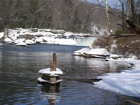 STATION.--03081500 YOUGHIOGHENY RIVER AT OHIOPYLE,
PA
STATION.--03081500 YOUGHIOGHENY RIVER AT OHIOPYLE,
PALOCATION.--Lat 39`52'15", long 79`29'35", Fayette County, Hydrologic Unit 05020006, on left bank 900 ft downstream from Route 381 highway bridge at Ohiopyle and 1,100 ft upstream from mouth of Meadow Run.
DRAINAGE AREA.--1,062 square miles.
PERIOD OF RECORD.--June 3, 2002 to current year.
GAGE.--Water-stage recorder and Pluvio precipitation gage. 1,164.2 ft above North American Vertical Datum of 1988. From November 1927 to October 1950, at site 1,400 ft upstream, datum 34.24 ft higher. Prior to January 4, 2024, the datum of gage was reported as 1,164.67 ft above National Geodetic Vertical Datum of 1929. The datum of gage was also erroneously reported as 1,164.67 ft above North American Vertical Datum of 1988 depending on source. Satellite telemetry at station.
COOPERATION.--Funding for the operation of this station is provided by the U.S. Army Corps of Engineers, Pittsburgh District.
GAGE HEIGHTS OF IMPORTANCE.-
Supplied by NWS: Action stage-10 ft; Flood stage-20 ft; Moderate flood stage-22 ft; Major flood stage-25 ft.
Summary of all available data for this site
Instantaneous-data availability statement


