PROVISIONAL DATA SUBJECT TO REVISION
Click to hidestation-specific text
Funding for this site is provided by:
 STATION.--395450075485401 CHESTER COUNTY, local well
number CH10
STATION.--395450075485401 CHESTER COUNTY, local well
number CH10LOCATION.--Lat 39`54'49.4", long 75`48'51.1", Hydrologic Unit 02040205, near intersection of SR 82 and 841, at Doe Run.
OWNER.--Privately owned.
AQUIFER.--Cockeysville Marble of Paleozoic age.
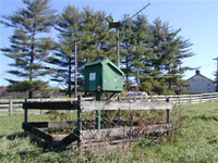
WELL CHARACTERISTICS.--Drilled unused water-table well, diameter 6 in, depth 34 ft, cased to 18 ft, open hole.
INSTRUMENTATION.--Data collection platform with 60-minute recording interval. Satellite telemetry at station.
DATUM.--Elevation of land surface is 293 ft above North American Vertical Datum of 1988, from Lidar. Measuring point: Top of plywood shelf, 5.2 ft above land-surface datum. Prior to June 24, 1981, top of casing 1.00 ft above land-surface datum.
REMARKS.--Daily maximum, minimum, and mean water levels since October 1994 are available from the District Office.
PERIOD OF RECORD.--August 1951 to April 1965, instantaneous water levels obtained several times per month. February 1966 to current year.
COOPERATION.--Funding for the operation of this station is provided by the U.S. Geological Survey.
This gage is monitored as part of the National Groundwater and Streamflow Information Program.
Summary of all available data for this site
Instantaneous-data availability statement
