PROVISIONAL DATA SUBJECT TO REVISION
Click to hidestation-specific text
| Funding for this site is provided by the cooperators / programs below: | |
|
Lower Colorado River Authority |
Cooperative Matching Funds |
|
|
|
| Rainfall Disclaimer | |
|
|
|
|
Retransmission, forecasts and summary by the National Weather Service |
|
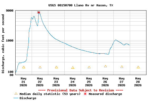
Datum of gage has been determined to be 1225.60 feet above NAVD 1988. To obtain water-surface elevations in NAVD 1988 add 1225.60 feet to gage height values.
Summary of all available data for this site
Instantaneous-data availability statement
![Graph of Gage height, feet, [Gage Height - Primary]](https://natwebvaww02.er.usgs.gov/nwisweb/data/img/USGS.08150700.141216.00065..20260521.20260528..0..gif)