USGS 08474107 Town Resaca at E 6th St, Brownsville, TX

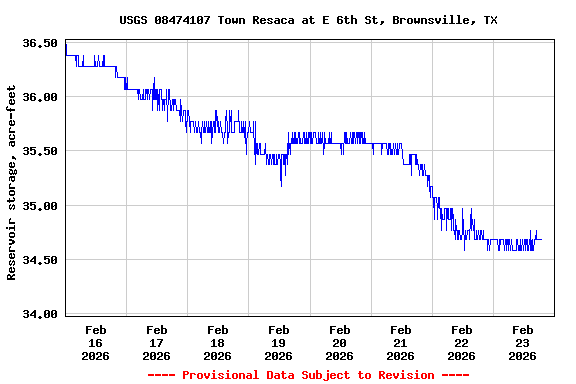
PROVISIONAL DATA SUBJECT TO REVISION

Click to hidestation-specific text

Datum of Gage is NAVD88

Funding for this site is provided by the cooperators / programs below:
Click to go to the City of Brownsville, TX web page

City of Brownsville, TX


Rainfall Disclaimer
Available Parameters Available Period
  
2022-04-27  2024-04-25
2022-03-17  2024-04-25
2022-04-01  2024-04-25
2022-03-16  2024-04-25


 (7)
 

  -- or --


Summary of all available data for this site
Instantaneous-data availability statement


Precipitation, total, inches

Most recent instantaneous value: 0.00 04-25-2024   17:45 CDT
Graph of  Precipitation, total, inches

Add up to 2 more sites and replot for "Precipitation, total, inches"

?


Create presentation-quality / stand-alone graph.   Subscribe to WaterAlert      

See this graph on the Monitoring Location Pages


Reservoir storage, acre-feet

Most recent instantaneous value: 34.38 04-25-2024   17:45 CDT
Graph of  Reservoir storage, acre-feet

Add up to 2 more sites and replot for "Reservoir storage, acre-feet"

?


Create presentation-quality / stand-alone graph.   Subscribe to WaterAlert      

See this graph on the Monitoring Location Pages


Discharge, cubic feet per second

Most recent instantaneous value: 1.19 04-25-2024   17:45 CDT
Graph of  Discharge, cubic feet per second

Add up to 2 more sites and replot for "Discharge, cubic feet per second"

?


Create presentation-quality / stand-alone graph.   Subscribe to WaterAlert      

See this graph on the Monitoring Location Pages


Gage height, feet

Most recent instantaneous value: 20.23 04-25-2024   17:45 CDT
Graph of  Gage height, feet

Add up to 2 more sites and replot for "Gage height, feet"

?


Create presentation-quality / stand-alone graph.   Subscribe to WaterAlert      

See this graph on the Monitoring Location Pages