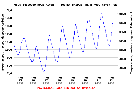
Most recent instantaneous value: 12.9 05-22-2026 13:30 PDT
See this graph on the Monitoring Location Pages
Station operated in cooperation with Bonneville Power Administration (BPA).
NOTE: River forecasts and additional data can be obtained at the
National Weather Service's Advanced Hydrologic Prediction Services web page.

NOTE: The most current shifted rating for this site can be found at USGS Rating Depot website.
| Boating safety tips |
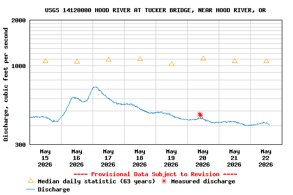
| Min (1992) | Most Recent Instantaneous Value May 22 | 25th percen- tile | Median | Mean | 75th percen- tile | Max (2008) |
|---|---|---|---|---|---|---|
| 407 | 409 | 774 | 1070 | 1150 | 1390 | 2960 |
![Graph of Gage height, feet, [(2)]](https://natwebvaww01.er.usgs.gov/nwisweb/data/img/USGS.14120000.116775.00065..20260515.20260522..0..gif)
![]() U.S. Department of the Interior |
U.S. Geological Survey
U.S. Department of the Interior |
U.S. Geological Survey
Title: USGS Current Conditions for the Nation
URL:
Page Contact Information: Oregon Water Data Support Team
Page Last Modified: 2026-05-22 17:09:01 EDT
2.45 1.79 vaww01