USGS 12043000 CALAWAH RIVER NEAR FORKS, WA

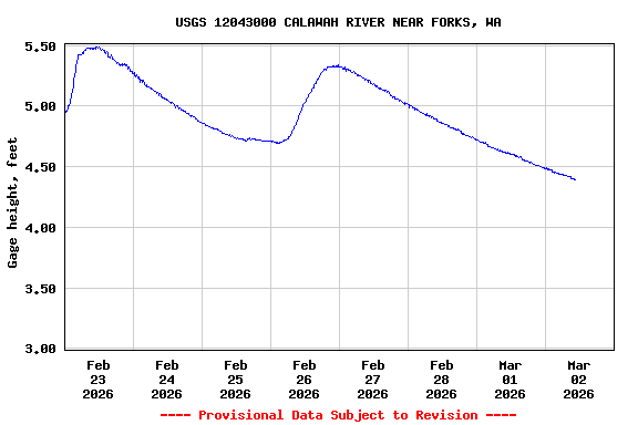
PROVISIONAL DATA SUBJECT TO REVISION

Click to hidestation-specific text
Arrow

Additional Data and Information.-- Latest shifted rating.

Action Stage.--The National Weather Service Action Stage for this station is 14.5 feet.

Funding for this site is provided by the cooperators / programs below:

Station Notes
funding
Due to a lack of funding, turbidity at this station was discontinued March 31, 2021. If you have any questions or to inquire about potentially funding this site, please use the "Questions" or "Feedback" links at the bottom of this page.

Boating safety tips

This station managed by the Western Washington Field Office (Tacoma).

Available Parameters Available Period
  
2019-12-17  2024-04-19
1989-10-01  2024-04-19
2007-10-01  2024-04-19
2018-09-20  2021-04-08


 (7)
 

  -- or --


Summary of all available data for this site
Instantaneous-data availability statement


Temperature, water, degrees Celsius

Most recent instantaneous value: 8.0 04-19-2024   12:30 PDT
Graph of  Temperature, water, degrees Celsius

Add up to 2 more sites and replot for "Temperature, water, degrees Celsius"

?


Create presentation-quality / stand-alone graph.   Subscribe to WaterAlert      

See this graph on the Monitoring Location Pages


Discharge, cubic feet per second

Most recent instantaneous value: 453 04-19-2024   12:30 PDT
Graph of  Discharge, cubic feet per second

Add up to 2 more sites and replot for "Discharge, cubic feet per second"

?


Create presentation-quality / stand-alone graph.   Subscribe to WaterAlert      

See this graph on the Monitoring Location Pages


Daily discharge, cubic feet per second -- statistics for Apr 19 based on 49 water years of record more
Min
(2004)
Most Recent
Instantaneous
Value Apr 19
25th
percen-
tile
Median Mean 75th
percen-
tile
Max
(1980)
300 453 581 887 952 1300 2970


Gage height, feet

Most recent instantaneous value: 3.74 04-19-2024   12:30 PDT
Graph of

Add up to 2 more sites and replot for "Gage height, feet"

?


Create presentation-quality / stand-alone graph.   Subscribe to WaterAlert      

See this graph on the Monitoring Location Pages