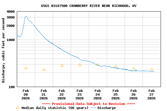
USGS 03187500 CRANBERRY RIVER NEAR RICHWOOD, WV

PROVISIONAL DATA SUBJECT TO REVISION

Click to hidestation-specific text
Station operated in cooperation with the U.S. Army Corps of Engineers - Huntington District and West Virginia Department of Environmental Protection

Current shift adjusted stage-discharge rating table. These tab delimited tables are updated daily and can change frequently. If you use these ratings, it is important that you update often so that you have the most current version.
What is a shift adjusted stage-discharge rating?

This station managed by the Charleston Field Office.

Available Parameters Available Period
  
2021-08-20  2026-02-20
2025-10-23  2026-02-20
1997-03-24  2026-02-20
2007-10-01  2026-02-20


 (7)
 

  -- or --


Summary of all available data for this site
Instantaneous-data availability statement


Discharge, cubic feet per second

Most recent instantaneous value: 1310 02-20-2026   06:30 EST
Graph of

Add up to 2 more sites and replot for "Discharge, cubic feet per second"

?


Create presentation-quality / stand-alone graph.   Subscribe to WaterAlert      

See this graph on the Monitoring Location Pages


Daily discharge, cubic feet per second -- statistics for Feb 20 based on 66 water years of record more
Min
(1977)
25th
percen-
tile
Median Mean 75th
percen-
tile
Most Recent
Instantaneous
Value Feb 20
Max
(1991)
38.0 121 252 328 436 1310 1530