Warning: Javascript must be enabled to use all the features on this page!


Page Loading - Please Wait...

Click to hideNews Bulletins
  • Due to a lapse in government funding, this website will not be updated except to provide important public safety information. For more information please visit: www.doi.gov/shutdown.
  • Explore the NEW USGS National Water Dashboard interactive map to access real-time water data from over 13,500 stations nationwide.
Click to hide state-specific text

! This page is undergoing modernization with expected decommissioning as key features are added to the modernized pages.
Learn more about our modernization plans to find out which options will suit you best. Next Generation Monitoring Location Page is available now.
A beta version of the My Favorites page is available in WDFN. Try it out and tell us what you think at wdfn@usgs.gov

PROVISIONAL DATA SUBJECT TO REVISION


USGS 01646500 POTOMAC RIVER NEAR WASH, DC LITTLE FALLS PUMP STA

Most recent instantaneous value: 1850 10-01-2025   15:50 EDTNext
Graph of

Add up to 2 more sites and replot for "Discharge, cubic feet per second"

?


Create presentation-quality / stand-alone graph.   Subscribe to WaterAlert      

See this graph on the Monitoring Location Pages


Daily discharge, cubic feet per second -- statistics for Oct 1 based on 95 water years of record more
Min
(1933)
25th
percen-
tile
Most Recent
Instantaneous
Value Oct 1
Median 75th
percen-
tile
Mean Max
(2005)
595 1540 1850 2510 5380 5980 63400

USGS 01648000 ROCK CREEK AT SHERRILL DRIVE WASHINGTON, DC

Most recent instantaneous value: 6.50 10-01-2025   15:15 EDTPrev   Next
Graph of  Discharge, cubic feet per second

Add up to 2 more sites and replot for "Discharge, cubic feet per second"

?


Create presentation-quality / stand-alone graph.   Subscribe to WaterAlert      

See this graph on the Monitoring Location Pages


Daily discharge, cubic feet per second -- statistics for Oct 1 based on 96 water years of record more
Min
(1931)
Most Recent
Instantaneous
Value Oct 1
25th
percen-
tile
Median 75th
percen-
tile
Mean Max
(1980)
0.50 6.50 12 20 39 52 948

USGS 01648010 ROCK CREEK AT JOYCE RD WASHINGTON, DC

Most recent instantaneous value: 7.37 10-01-2025   16:35 EDTPrev   Next
Graph of

Add up to 2 more sites and replot for "Discharge, cubic feet per second"

?


Create presentation-quality / stand-alone graph.   Subscribe to WaterAlert      

See this graph on the Monitoring Location Pages


Daily discharge, cubic feet per second -- statistics for Oct 1 based on 13 water years of record more
Most Recent
Instantaneous
Value Oct 1
Min
(2014)
25th
percen-
tile
Median Mean 75th
percen-
tile
Max
(2023)
7.37 8.70 18 28 60 90 197

USGS 01648011 Luzon Branch above Rock Creek at Washington DC

Most recent instantaneous value: 0.36 10-01-2025   15:10 EDTPrev   Next
Graph of  Discharge, cubic feet per second

Add up to 2 more sites and replot for "Discharge, cubic feet per second"

?


Create presentation-quality / stand-alone graph.   Subscribe to WaterAlert      

See this graph on the Monitoring Location Pages


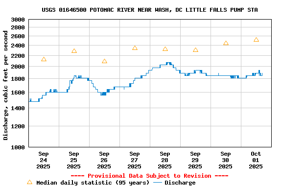
Daily discharge, cubic feet per second -- statistics for Oct 1 based on 3 water years of record more
Most Recent
Instantaneous
Value Oct 1
Min
(2024)
25th
percen-
tile
Mean Median 75th
percen-
tile
Max
(2023)
0.36 0.40 0.4 3 3.9 4.6 4.62

USGS 01651000 NORTHWEST BR ANACOSTIA RIVER NR HYATTSVILLE, MD
*** There are no data available on the Waterdata system for the time period specified,
    although data may be available in the files of the local USGS office operating the station.

USGS 01651730 BEAVERDAM CREEK NEAR CHEVERLY, MD

Discharge, cubic feet per second
 
-- Data temporarily unavailable for the time period specified --

USGS 01651760 ANACOSTIA RIVER AT KENILWORTH AT WASHINGTON, DC

Most recent instantaneous value: 357 10-01-2025   16:35 EDTPrev   Next
Graph of  Discharge, cubic feet per second

Add up to 2 more sites and replot for "Discharge, cubic feet per second"

?


Create presentation-quality / stand-alone graph.   Subscribe to WaterAlert      

See this graph on the Monitoring Location Pages


USGS 01651770 HICKEY RUN AT NATIONAL ARBORETUM AT WASHINGTON, DC

Most recent instantaneous value: 0.07 10-01-2025   15:08 EDTPrev   Next
Graph of  Discharge, cubic feet per second

Add up to 2 more sites and replot for "Discharge, cubic feet per second"

?


Create presentation-quality / stand-alone graph.   Subscribe to WaterAlert      

See this graph on the Monitoring Location Pages


Daily discharge, cubic feet per second -- statistics for Oct 1 based on 13 water years of record more
Most Recent
Instantaneous
Value Oct 1
Min
(2020)
25th
percen-
tile
Median Mean 75th
percen-
tile
Max
(2016)
0.07 0.14 0.17 0.44 1.7 3 8.90

USGS 01651800 WATTS BRANCH AT WASHINGTON, DC

Most recent instantaneous value: 0.52 10-01-2025   16:38 EDTPrev   Next
Graph of

Add up to 2 more sites and replot for "Discharge, cubic feet per second"

?


Create presentation-quality / stand-alone graph.   Subscribe to WaterAlert      

See this graph on the Monitoring Location Pages


Daily discharge, cubic feet per second -- statistics for Oct 1 based on 33 water years of record more
Min
(2003)
Most Recent
Instantaneous
Value Oct 1
25th
percen-
tile
Median Mean 75th
percen-
tile
Max
(2016)
0.28 0.52 0.64 1.2 2.8 3 17.3

USGS 01651827 Anacostia River nr Buzzard Point at Washington, DC

Most recent instantaneous value: -1400 10-01-2025   16:35 EDTPrev   Next
Graph of  Discharge, cubic feet per second

Add up to 2 more sites and replot for "Discharge, cubic feet per second"

?


Create presentation-quality / stand-alone graph.   Subscribe to WaterAlert      

See this graph on the Monitoring Location Pages


USGS 01652500 FOURMILE RUN AT ALEXANDRIA, VA

Most recent instantaneous value: 3.71 10-01-2025   16:35 EDTPrev   Next
Graph of  Discharge, cubic feet per second

Add up to 2 more sites and replot for "Discharge, cubic feet per second"

?


Create presentation-quality / stand-alone graph.   Subscribe to WaterAlert      

See this graph on the Monitoring Location Pages


Daily discharge, cubic feet per second -- statistics for Oct 1 based on 51 water years of record more
Min
(1958)
25th
percen-
tile
Most Recent
Instantaneous
Value Oct 1
Median 75th
percen-
tile
Mean Max
(1980)
1.50 3 3.71 4.2 14 24 372

USGS 01653000 CAMERON RUN AT ALEXANDRIA, VA

Most recent instantaneous value: 8.72 10-01-2025   16:05 EDTPrev   Next
Graph of  Discharge, cubic feet per second

Add up to 2 more sites and replot for "Discharge, cubic feet per second"

?


Create presentation-quality / stand-alone graph.   Subscribe to WaterAlert      

See this graph on the Monitoring Location Pages


Daily discharge, cubic feet per second -- statistics for Oct 1 based on 64 water years of record more
Min
(1969)
25th
percen-
tile
Median Most Recent
Instantaneous
Value Oct 1
75th
percen-
tile
Mean Max
(1980)
1.60 5 8.1 8.72 31 53 1500