Explore the NEWUSGS National Water Dashboard interactive map to access real-time water data from over 13,500 stations nationwide.
Discrete water samples data are undergoing modernization with this page no longer being updated with the latest data
starting March 11, 2024
with a full decommission expected 6 months later.
Learn more about the upcoming change and where to find the new samples
data in our blog.
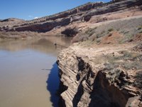
Colorado River near Cisco, Utah looking upstream at the reference
gage. 7,280 cubic feet per second, 4.01 feet gage height.
Station operated by the U.S.
Geological Survey as part of the Federal Priority Streamgages Network,
in cooperation with the U.S. Bureau of Reclamation. Visit
USGS Real-Time Water Quality to view continuous estimates of
concentrations and loads for bacteria and other chemicals.