LOCATION.--Lat 40°35'20.61", long
73°57'55.60" referenced to North American Datum of
1983, Kings County, NY, Hydrologic Unit 02030202,
WELL CHARACTERISTICS.--Depth 30 ft. Upper casing
diameter 2 in; top of first opening 20 ft, bottom of last
opening 25 ft.
DATUM.--Land-surface datum is 7.65 ft above North
American Vertical Datum of 1988. Measuring point: MP on N/S of
2 in PVC Casing, 7.3 ft above land-surface datum, Jul. 27, 2009
to present.
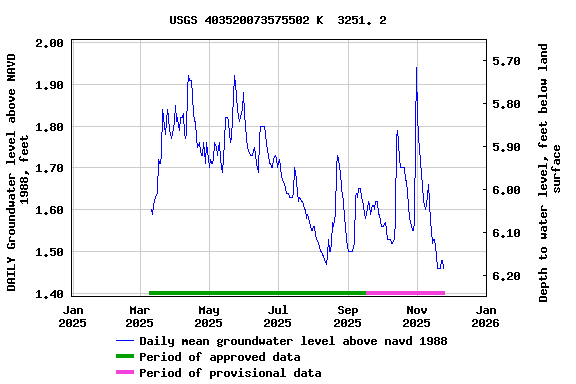
PERIOD OF RECORD.--April 2011 to March 2013, July 2024
to current year.
GAGE.--Periodic manual measurements by USGS
personnel.
EXTREMES FOR PERIOD OF RECORD.--Highest water level
measured, 2.36 ft above NAVD of 1988, Aug. 17, 2011; lowest
measured, 1.47 ft above NAVD of 1988, Mar. 16, 2012, Feb. 19,
2013.
 Site Information
 WaterAlert – get an
email or text (SMS) alert based on your chosen threshold.
WaterAlert – get an
email or text (SMS) alert based on your chosen threshold. Station image