LOCATION.--Lat 40°47'50", long
73°57'18" referenced to North American Datum of 1927,
New York County, NY, Hydrologic Unit 02030101, at Central Park,
28 ft west of Central Park East Drive, just south of Central
Park North Drive, Manhattan.
WELL CHARACTERISTICS.--Depth 75 ft. Upper casing
diameter 3 in; top of first opening 18 ft, bottom of last
opening 75 ft. Cased to 18 ft, open hole.
DATUM.--Land-surface datum is 27 ft above National
Geodetic Vertical Datum of 1929. Measuring point: Top of
casing, 0.25 ft below land-surface datum, 26.75 ft above
land-surface datum, Jun. 22, 2005 to present.
PERIOD OF RECORD.--October 2005 to April 2013, July 2024
to current year.
GAGE.--Periodic manual measurements by USGS
personnel.
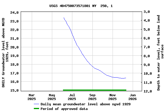
EXTREMES FOR PERIOD OF RECORD.--Highest water level
measured, 24.37 ft above NGVD of 1929, Apr. 18, 2011; lowest
measured, 14.65 ft above NGVD of 1929, Oct. 24, 2008.
 Site Information
 WaterAlert – get an
email or text (SMS) alert based on your chosen threshold.
WaterAlert – get an
email or text (SMS) alert based on your chosen threshold. Station image