LOCATION.--Lat 40°50'10.0", long
73°41'48.1" referenced to North American Datum of
1983, Nassau County, NY, Hydrologic Unit 02030201, at Port
Washington Water District, north side of Bayside Avenue, Port
Washington.
WELL CHARACTERISTICS.--Depth 384 ft. Upper casing
diameter 4 in; top of first opening 364 ft, bottom of last
opening 384 ft.
DATUM.--Land-surface datum is 17 ft above National
Geodetic Vertical Datum of 1929. Measuring point: Top of
casing, 0.88 ft below land-surface datum, 16.12 ft above
National Geodetic Vertical Datum of 1929, Jul. 30, 1993 to Dec.
31, 2005; N/S of 4inch pvc casing, 16.14 ft above National
Geodetic Vertical Datum of 1929, Jun. 12, 2013 to
present.
PERIOD OF RECORD.--July 1993 to March 1997, March 2002
to current year.
GAGE.--Periodic manual measurements by USGS
personnel.
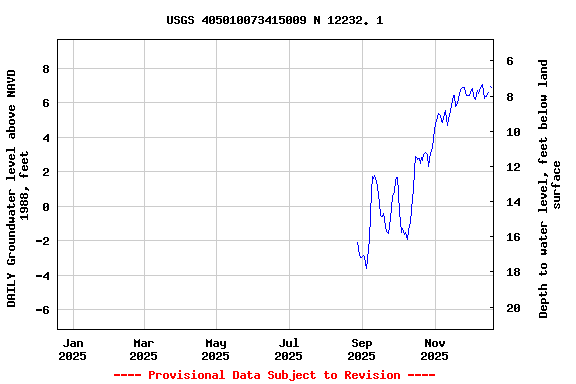
EXTREMES FOR PERIOD OF RECORD.--Highest water level
measured, 11.41 ft above NGVD of 1929, Mar. 26, 2013; lowest
measured, 3.96 ft below NGVD of 1929, July 24, 2013.
 Site Information
 WaterAlert – get an
email or text (SMS) alert based on your chosen threshold.
WaterAlert – get an
email or text (SMS) alert based on your chosen threshold. Station image