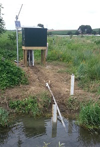
 STATION.
--015765185 Unnamed Tributary to Big Spring
Run near Willow Street, PA
LOCATION.--Lat 39`59'28.29", long
76`15'50.23", Lancaster County, Hydrologic Unit
02050306.
DRAINAGE AREA.--1.05 square miles.
PERIOD OF RECORD.--October 2008 to October 2017
(discontinued).
GAGE.--Water-stage recorder, crest-stage gage, and
water-quality recorder with electronic data logger. Elevation of gage
is 322 ft above North American Vertical Datum of 1988, from Lidar.
Prior to July 2, 2015, gage at datum one foot lower.
COOPERATION.--Station established and maintained by
the U.S. Geological Survey. Funding for the operation of this station
is provided by the Pennsylvania Department of Environmental
Protection.
REMARKS.--Satellite telemetry at station.
 STATION.--015765185 Unnamed Tributary to Big Spring
Run near Willow Street, PA