Location.--Latitude 46°51'08", Longitude
122°40'03", in SE 1/4 SW 1/4 Section 22, Township 16 North,
Range 1 East, in Thurston County, Hydrologic Unit 17110016, on
right bank 100 feet upstream from county road crossing, 0.4 mile
downstream from outlet of Reichel Lake, 2.7 miles southeast of Rainier,
and at river mile
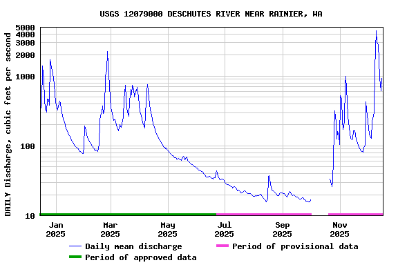
25.9. Drainage
area is 89.8 mi2. Datum of
gage is 348.77 feet above NGVD of 1929.
Maps.--Locate
this station on a
map of the basin (PDF).
Additional Data and Information.-- Latest shifted rating.
Flood Stage.--The National Weather Service Flood
Stage for this station is 11.0 feet. Thurston County has Flood
Information for this gage.
Funding for this site is provided by the
cooperators / programs below:
To determine water level in feet
above sea level:
add current gage reading +349.11
(NAVD88 datum, levels of September 26, 2019)
Boating safety tips