Warning: Javascript must be enabled to use all the features on this page!


Page Loading - Please Wait...

* We've detected you're using a mobile device. Find our Next Generation Station Page here.
Click to hideNews Bulletins

USGS 12322000 KOOTENAI RIVER AT PORTHILL ID

PROVISIONAL DATA SUBJECT TO REVISION

Click to hidestation-specific text
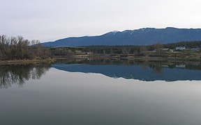
Kootenai River at Porthill, ID - USGS file photo

International gaging station

Starting in water year 2014, daily mean discharge values are presented only for the discharge measured at 12322000. Prior to water year 2014, the daily mean discharge values represented the total discharge passing the international boundary, which included inflows from Boundary Creek. Total discharge passing the international boundary is now available under station 12322001.

Station is operated in cooperation with the U.S. Army Corps of Engineers and the International Joint Commission.

This station managed by the Post Falls Field Office.

Available Parameters Period of Record
  
1963-05-23  2024-11-20
2013-10-01  2024-11-20
1960-10-01  2024-11-20
1983-10-01  1989-12-25
2018-12-31  2024-11-20
1983-10-01  1989-09-29
1983-10-01  1989-09-29
2018-12-31  2024-11-20


 (365)
 

  -- or --


Summary of all available data for this site
Instantaneous-data availability statement


Temperature, water, degrees Celsius


Graph of DAILY Temperature, water, degrees Celsius

Add up to 2 more sites and replot for "Temperature, water, degrees Celsius"

?


Create presentation-quality graph.  


Discharge, cubic feet per second


Graph of DAILY Discharge, cubic feet per second

Add up to 2 more sites and replot for "Discharge, cubic feet per second"

?


Create presentation-quality graph.  


Gage height, feet


Graph of DAILY Gage height, feet

Add up to 2 more sites and replot for "Gage height, feet"

?


Create presentation-quality graph.  


Discharge, cubic meters per second, [m^3/s]


Graph of DAILY Discharge, cubic meters per second, [m^3/s]

Add up to 2 more sites and replot for "Discharge, cubic meters per second, [m^3/s]"

?


Create presentation-quality graph.  


Gage height, above datum, meters, [Meters]


Graph of DAILY Gage height, above datum, meters, [Meters]

Add up to 2 more sites and replot for "Gage height, above datum, meters, [Meters]"

?


Create presentation-quality graph.