LOCATION.--Lat 40°35'02.82", long
74°09'40.57" referenced to North American Datum of
1983, Richmond County, NY, Hydrologic Unit 02030104,
WELL CHARACTERISTICS.--Depth 25 ft. Upper casing
diameter 2 in; top of first opening 15 ft, bottom of last
opening 20 ft.
DATUM.--Land-surface datum is 54.6 ft above North
American Vertical Datum of 1988. Measuring point: North side
top of 2 inch PVC casing, 54.4 ft above North American Vertical
Datum of 1988, Oct. 25, 2007 to Sep. 18, 2024; North side top
of 2 inch PVC casing, 54.61 ft above North American Vertical
Datum of 1988, Sep. 18, 2024 to present.
PERIOD OF RECORD.--October 2007 to April 2015, June 2024
to current year.
GAGE.--Periodic
manual measurements by USGS personnel.
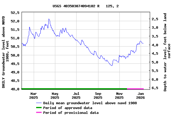
EXTREMES FOR PERIOD OF RECORD.--Highest water level
measured, 52.53 ft above NAVD of 1988 (53.60 ft above NGVD of
1929), Mar. 24, 2010; lowest measured, 49.81 ft above NAVD of
1988 (50.88 ft above NGVD of 1929), Sept. 27, 2010.
 Site Information
 WaterAlert – get an
email or text (SMS) alert based on your chosen threshold.
WaterAlert – get an
email or text (SMS) alert based on your chosen threshold. Station image