LOCATION.--Lat 40°38'40", long
73°59'21" referenced to North American Datum of 1927,
Kings County, NY, Hydrologic Unit 02030202, at north side of
Fort Hamilton Parkway, 176 ft east of 37th Street, Borough
Park.
WELL CHARACTERISTICS.--Depth 75 ft. Upper casing
diameter 2 in; top of first opening 70 ft, bottom of last
opening 75 ft.
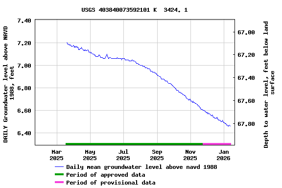
DATUM.--Land-surface datum is 75.4 ft above National
Geodetic Vertical Datum of 1929. Measuring point: Top of
coupling. 0.03 ft below land-surface datum, 75.37 ft above
land-surface datum, Mar. 14, 1995 to present.
PERIOD OF RECORD.--March 1995 to April 2015, July 2024
to current year.
GAGE.--Periodic manual measurements by USGS
personnel.
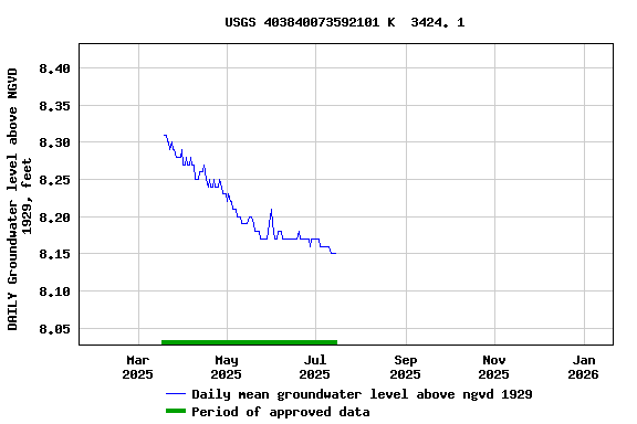
EXTREMES FOR PERIOD OF RECORD.--Highest water level
measured, 9.32 ft above NGVD of 1929, July 28, 1998; lowest
measured, 6.62 ft above NGVD of 1929, Aug. 30, 2002.
 Site Information
 WaterAlert – get an
email or text (SMS) alert based on your chosen threshold.
WaterAlert – get an
email or text (SMS) alert based on your chosen threshold. Station image