LOCATION.--Lat 40°40'26", long
73°47'21" referenced to North American Datum of 1927,
Queens County, NY, Hydrologic Unit 02030202, at east side of
Stuphin Boulevard, 226 ft north of Rockaway Boulevard,
Springfield Gardens.
WELL CHARACTERISTICS.--Depth 320 ft. Upper casing
diameter 4 in; top of first opening 310 ft, bottom of last
opening 320 ft.
DATUM.--Land-surface datum is 23 ft above National
Geodetic Vertical Datum of 1929. Measuring point: Top of
northside of well casing, 22.46 ft above land-surface datum,
Mar. 16, 1995 to Mar. 27, 2024; Top of northside of well
casing, 21.124 ft above land-surface datum, Mar. 27, 2024 to
present.
PERIOD OF RECORD.--March 1995 to April 2015, March 2024
to current year.
GAGE.--Water level logger installed August 2024 to
September 2024. Periodic manual measurements by USGS
personnel.
REMARKS.--Water level affected by local
dewatering.
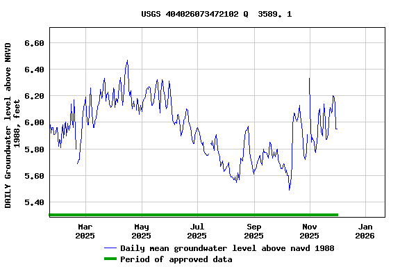
EXTREMES FOR PERIOD OF RECORD.--Highest measured, 6.93
ft above NAVD of 1988 (8.03 ft above NGVD of 1929), Apr. 2,
2010; lowest measured, 0.04 ft below NAVD of 1988 (1.06 ft
above NGVD of 1929), Oct. 28, 1998.
 Site Information
 WaterAlert – get an
email or text (SMS) alert based on your chosen threshold.
WaterAlert – get an
email or text (SMS) alert based on your chosen threshold. Station image