LOCATION.--Lat 40°41'24.6", long
73°39'47.2" referenced to North American Datum of
1983, Nassau County, NY, Hydrologic Unit 02030202, at west side
of Euclid Avenue, 30 ft south of Hawthorne Street, West
Hempstead.
WELL CHARACTERISTICS.--Depth 55 ft. Upper casing
diameter 2 in; top of first opening 45 ft, bottom of last
opening 50 ft. Datum of gage is NGVD of 1929.
DATUM.--Land-surface datum is 49.45 ft above North
American Vertical Datum of 1988. Measuring point: Last leveled
with DGPS on 06-23-2015, 50.08 ft above land-surface datum,
Oct. 2, 2002 to Mar. 22, 2016; unknown, 50.14 ft above
land-surface datum, Mar. 22, 2016 to Feb. 8, 2019; Top of 2
inch PVC casing, north edge, 50.1 ft above land-surface datum,
Feb. 8, 2019 to Oct. 23, 2023; Top of 2 inch PVC casing, north
edge, 50.15 ft above land-surface datum, Oct. 23, 2023 to Aug.
8, 2024; Top of 2 inch PVC casing, north edge, 49.03 ft above
land-surface datum, Aug. 8, 2024 to present.
PERIOD OF RECORD.--October 2002 to current year.
GAGE.--Water-level recorder installed October 2002 to
September 2024; 15-minute recording interval. Periodic manual
measurements made by USGS personnel.
REMARKS.--Replaced well N 1129. 2 in October 2002 near
same location. Cellular water-level telemeter at station.
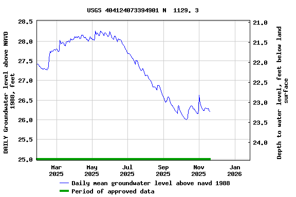
EXTREMES FOR PERIOD OF RECORD.--Highest water level
recorded, 30.96 ft above NAVD of 1988, July 23, 2019; lowest
recorded, 22.38 ft above NAVD of 1988, Nov. 6, 2002.
 Site Information
 WaterAlert – get an
email or text (SMS) alert based on your chosen threshold.
WaterAlert – get an
email or text (SMS) alert based on your chosen threshold.